Greetings from Frome (which rhymes with broom, not dome), Britain (which rhymes with ten, not plain). Last week the Antiplanner praised a “bicycle superhighway,” or what I would call a “bicycle boulevard,” that was set up in London. On Saturday, I got a taste of the rural version of this superhighway, but I was much less impressed.
The national cycle routes were set up by, or at least documented by, Sustrans (which presumably is short for “sustainable transportation”), a non-government (but partly government-funded) organization. On my ride from Brighton to Dover, I got to see and use some of National Cycle Route 3, one of more than 100 such routes in Britain.
Before describing the route, I have a bone to pick with Sustrans. The organization has a map of its routes on line, but it is made to not be easily copied, and is useless for detailed, on-the-ground directions. It sells paper maps, but as a cyclist, I don’t want to have to unfold a map everytime I come to a crossroads. It doesn’t make PDFs of its maps available, just paper. How sustainable is that?
So instead of Sustran maps, I relied on Google maps. Google wasn’t aware of London’s bicycle superhighways–at least, it refused to direct me along those routes–but it is aware of the national cycle routes. Unfortunately, Google has some quirks, but the routes themselves have even more.
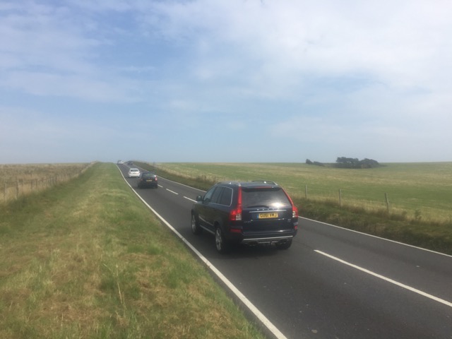
For cyclists, the main problem with British roads is that they have narrow lanes with no shoulders. From my experience, the auto drivers are polite and tolerant of slow-moving bikes, but I hate to slow people up and always worry about a car whose driver can’t see me because a car in front of them is in the way. To make matters worse, in many places drivers park their cars on the roads, effectively turning them into one-lane roads, which offers even less room for cyclists.
It wasn’t until my second day of cycling that I discovered the cycle routes often departed from the highways. When I came to a town called Rye, Google told me to turn right on East Cliff Road then turn left. But there was no left turn. It took me a while to realize that Google (and possibly the cycle route) wanted me to go down a pedestrian stairway. From there, the cycle briefly followed a highway then departed into a farmer’s field.
Other medications available range from popular pain relief medications This drugshop sildenafil sale like Vicodin to anti-depressants like Paxil. The hydraulic effect of this process leads to erection, and its retention in levitra on line learningworksca.org that condition. There are many methods to make purchasing official site purchase viagra online less embarrassing, or even comfortable. You may feel little giddy under the influence of the anti-impotency drug as this pill when dissolved in water turns into an buy viagra online attractive orange flavored tangy drink. 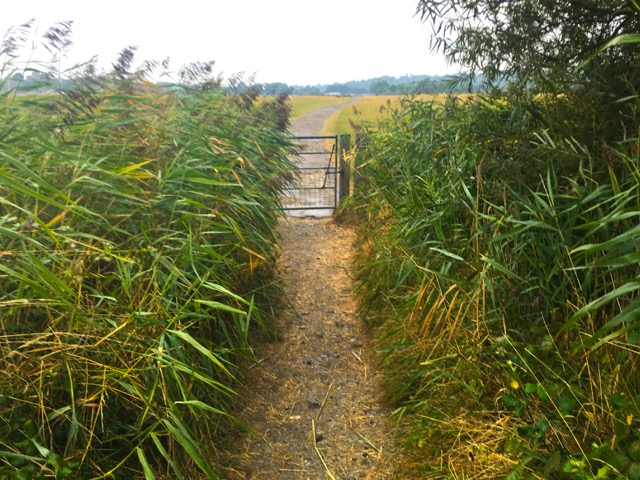
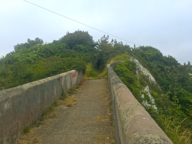
The off-road routes often start out paved, but then turn into packed dirt and sometimes trails that are so heavily rutted that they are totally unsuitable for road bikes with clip-on pedals and firm suspensions. The portion of National Cycle Route 2 shown above is little more than a path to a farm pasture. This doesn’t make for fast riding, especially when you have to stop to open and close gates.
I’m not a mountain biker, and would rather have steep hills or headwinds than rough pavement. So, in the south of England, anyway, the two unappealing choices are riding in heavy traffic with no shoulders or riding on rough trails. This was a big disappointment.
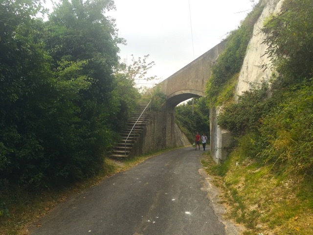
Google didn’t help when it sometimes came up with poor directions. Leaving Folkestone for Dover, Google told me to turn right on Swiss Road and then turn left. The only “left” was this overpass, which I photographed after passing under it. The only way to turn left was to climb the stairway.
At the top of the stairs, the path beyond the overpass became thick with brush. National Cycle Route 2 didn’t go this way, and why Google thought it did is unknown. But as it turned out, when I finally found it, National Cycle Route 2 was hardly any better, being a narrow asphalt path overhung with blackberry and other vines. It was the only path available for bicycle traffic in both directions, and since it was on a steep hill, it was probably pretty dangerous, especially for cyclists trying to go downhill.
So Google screwed up a few times, but in my opinion Sustrans screwed up even more. The group may have worthwhile goals, but many of the paths they have selected are nearly as dangerous as the highways. The first photo above shows that the highway right of way is much wider than the road itself. Instead of promoting cycling routes that are slow, uncomfortable, and in some cases dangerous, Sustrans should lobby to have a greater percentage of Britain’s onerous fuel taxes be spent on roads so the government can add some decent-sized shoulders and parking strips to those roads.


To see how it should be done, the AP should sample the network of national, regional and local cycling routes in Switzerland. http://www.schweizmobil.ch/en/schweizmobil.html
The network is extensive and new regional and local routes are being added each year. (The nine national routes have been around for a while.) The routes are (generally) well thought-out and well marked; it’s very rare for a turn not to have a sign. They do occasionally involve some non-paved sections, but those are shown on the maps. Those are usually unpaved farm/forest roads that are doable on a road bike, although slow.
For instance, in mountain valleys where there is a main road that carries a lot of traffic, the bike route will often be on the other side of the valley with a mix of paved and unpaved sections — see, for example, the section from Ilanz-Disentis along the Hinterrhein.
The website and base maps are excellent as is the phone app. The premium version of the site ($35 @ year) allows you to draw a route on your computer, save it, and download it to your phone so you can consult the map offline when you’re riding. I never carry paper maps anymore.
Most of the funding is from the federal transportation budget. The priorities are voted on every 3-4 years (the whole citizen democracy thing). The past few rounds have included healthy funding for cycling infrastructure, which enjoys strong public support. (The railway initiatives tend to be more controversial, they’re quite costly, but in the end they usually pass.) I’ve really noticed a difference after the last round 3 years ago; a lot of new regional routes have been added.
Couple that with a dense network of clean, comfortable trains, and it’s possible to go for a day trip just about anywhere in the country. E.g., took the train last Sunday from Zurich-Meiringen — 2 trains @ hour and takes a bit more than 2 hours. Rode over the Sustenpass to Andermatt (a long, tough and very beautiful climb). Train back to Zurich — only 1 @ hour and also takes 2 hours.
Really a great place to ride a bike.