Researchers: Logging Won’t Stop Fires

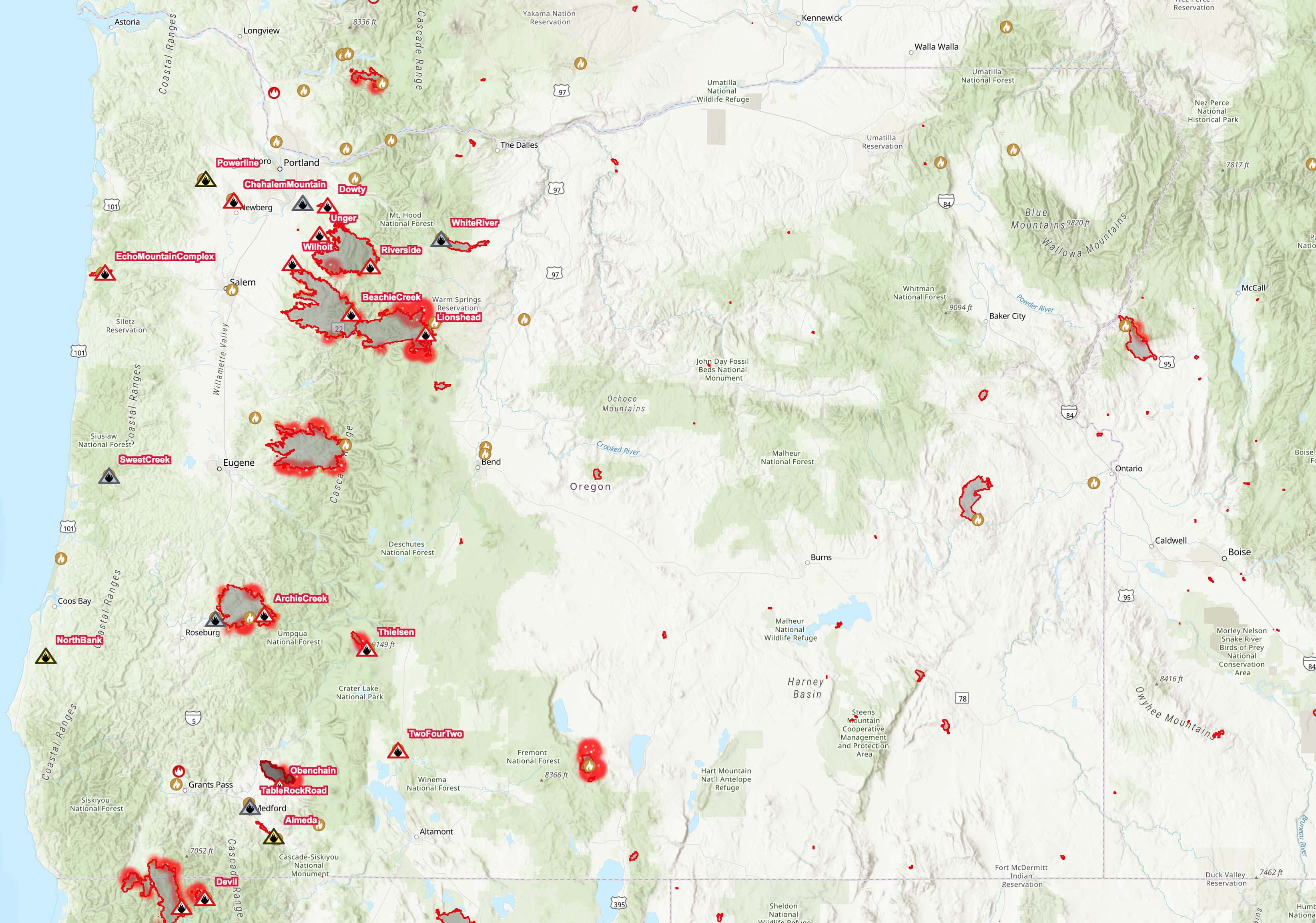
Despite rain in the valleys and snow in the mountains, wildfires are still smoldering in Oregon and people are still trying to blame those fires on the lack of government spending on logging or prescribed burning. Yet increased logging wouldn’t have stopped western wildfires this year, a number of researchers told reporters in an article jointly written by the Oregonian, Oregon Public Broadcasting, and Propublica.

“The belief people have is that somehow or another we can thin our way to low-intensity fire that will be easy to suppress, easy to contain, easy to control,” retired Forest Service researcher Jack Cohen told the reporters. “Nothing could be further from the truth.” Continue reading

It’s Not Climate Change, Stupid

Early this week, Oregon governor Kate Brown went on national television to call the Pacific Coast fires a “bellwether for climate change.” As UC Berkeley professor of sustainable development Maximilian Auffhammer writes, “It’s the climate change, stupid.”

This is one of four responses to the Pacific Coast fires. Brown and Auffhammer are warmers, people who believe the earth’s climate is changing and the fires must be due to that change. In the warmers’ minds, the fires themselves then become evidence that we need to change our lifestyles to cut back on greenhouse gas emissions.

A second group are the burners, people who believe that a century of fire suppression has led to a dangerous build-up of fuels in the forests. Oregon Senator Ron Wyden falls into this category. He wants to give the Forest Service and other agencies more money and more freedom to do prescribed burning. Continue reading

Wildfire Update

Wildfires continue to burn out of control in much of Oregon, California, and Washington, though they aren’t expanding as fast as they did during last Monday’s wind storm. Most of the Northwest is under a blanket of smoke that is hazardous to our health; the good news is the smoke is cooling temperatures by 10 degrees or so, thus reducing the rate of spread of the fires.

About 1.5 percent of Oregon has burned in the last week with an unusual number of fires burning nearly to the borders of cities such as Ashland, Medford, Oregon City, Roseburg, Salem, and Springfield. Click image for a larger view. Map from Firemappers.

Yesterday’s national situation report was the first I have seen this year in which the number of acres burned exceeded the ten-year average through this date. I downloaded the previous ten years of September 13 reports and found that the Pacific Coast states, central Rockies, and Southwest have all seen more acres burn than the ten-year average, but Alaska, the Northern Rockies, Great Basin, East, and South are well below average. Continue reading

Burning 3 Acres Per Second

On Monday morning, September 7, the Beachie Creek Fire had burned 776 acres in the Opal Creek Wilderness of the Willamette National Forest. The fire was in a steep, inaccessible landscape, so the Forest Service had been fighting it mainly by dropping water from helicopters.

Dropping water on the Beachie fire on September 2, when it was supposed to be only 23 acres in size. Click image for a larger view. Forest Service photo.

Monday afternoon saw winds as high as 75 miles per hour blowing burning embers from the fire miles to the west. Over the next ten or so hours, the fire burned an average of three acres per second, growing to 132,450 acres. Residents of Gates, Mill City, and Mehama who had gone to sleep knowing they were comfortably 4 to 7 miles from the fire front were awakened and hastily evacuated in the middle of the night. The now-renamed Santiam Fire destroyed hundreds of homes and killed at least two people. Continue reading

Is Aerial Firefighting Cost-Effective?

Last Wednesday afternoon, I watched four large airtankers drop tens of thousands of gallons of fire retardant on the Green Ridge Fire, which is burning within sight of my backyard. The airtankers included two twin-jet MD-87s, a DC-7, and a CV-580.

A DC-7 dumps 3,000 gallons of retardant on an area already painted red with the stuff to try to keep the fire on the left from to the right (south) overnight. Click image for a larger view.

Between them, the four planes were capable of dumping more than 11,000 gallons of retardant, and they each made several passes at the fire. A west wind was pushing most of the fire to the east, but there was also some push to the south. The tankers were painting a wide swath of forest red south of the burning area to try to slow or halt the southerly expansion of the fire. Continue reading

Green Ridge Fire

A thunderstorm Sunday afternoon ignited more than two dozen fires in Central Oregon. Most were quickly suppressed and the largest one still burning is within sight of my backyard, which means we have been treated to a noisy air show of helicopters and MD-87s dumping water or fire retardant on the hillside.

Looking like a tiny insect, a helicopter dumps water on the north side of the Green Ridge fire on Monday. Despite these efforts, the fire appeared to have spread north of this spot on Tuesday. Click image for a larger view.

Due to drought, many fire officials were predicting that wildfires this year would be “severe and complex,” particularly in the West. In fact, according to the National Interagency Coordination Center’s Tuesday morning situation report, only 53 percent as many acres have burned so far this year as the average of the last ten years. Fewer acres have burned so far this year than burned by this same date in 2014, which was the mildest fire year since 2010. Continue reading

Low-Density Fire Buffer

Someone in Bend must be reading this blog, or at least thinking along the same lines. In 2017, after the Wine Country fires had burned homes in Santa Rose, the Antiplanner noted that the problem was the homes were too dense and needed a buffer of low-density homes around them. I made the same point after the Camp Fire burned homes in Paradise.

Now Deschutes County is zoning a buffer between Bend and the national forest for low-density housing. The zone calls for one home every 2.5 acres, which is probably not dense enough — one home every acre would be sufficient and would make it more likely that homeowners would treat their entire properties to minimize fire risk.

The land that Deschutes County is zoning as a fire buffer is outside of Bend’s urban-growth boundary. Under Oregon land-use planning rules, lands outside of but adjacent to the boundary may be zoned “rural residential” with 5- to 10-acre minimum lot sizes. It is likely that the county is going for 2.5-acre lot sizes because it fears it couldn’t get away with one-acre lot sizes. Continue reading

The Camp Fire

When the Antiplanner looks at before-and-after aerial photos of the fire in Paradise, California that killed at least 84 people, the first thing I think is that, like last year’s Santa Rosa fire, the houses were built too closely together. This made it impossible, short of building a home exclusively of concrete, to defend homes from fire. Once one house caught on fire, its neighbors would be ignited by the radiant heat of the first.

As described in a Los Angeles Time article, the best way to prevent such “structure to structure ignition” is to build homes at least 100 feet apart. California law in fact requires that homeowners provide a 100-foot perimeter of “defensible space,” but the law doesn’t require that homes be built 100 feet apart. As the Times notes, the “100-foot requirement stops at the property line.”

Unfortunately, urban planners’ mania for density makes it difficult, if not impossible, for California developers to lay out homesites on one-acre lots, which would insure at least 100 feet between homes. While I don’t know the situation in Paradise, population data indicate that much of the growth of the city has been since 1970, when many California cities and counties began limiting low-density development. Continue reading

The Sordid History of Forest Service Fire Data

The latest wildfire situation report indicates that about 7.3 million acres have burned to date this year. That’s about 1.2 million acres less than this same date last year, but about 1.5 million acres more than the ten-year average and a lot more than the average in the 1950s and 1960s, which was about 3.9 million acres a year.

Some people use the data behind this chart to argue against anthropogenic climate change. The problem is that the data before about 1955 are a lie. Click image to go to the source data.

While some blame the increase in acres burned on human-caused climate change, skeptics of anthropogenic warming have pointed out that, according to the official records, far more acres burned in the 1930s — close to 40 million acres a year — than in any recent decade. The 1930s were indeed a decade of unusually bad droughts that can’t be blamed on anthropogenic climate change. Continue reading

The Wildfires of Summer

It’s the height of summer, which means the Antiplanner is thinking about hiking in nearby national forests before they get filled with smoke from wildfires. This year has already seen 3.4 million acres burn, mostly in the South and the Rocky Mountains. That’s slightly more than average, but big fires in the Pacific Coast states have yet to come.

A friend of mine forwarded to me a copy of a letter from a retired logger to his Congressional delegation criticizing the Forest Service and other federal land agencies for their firefighting tactics. He remembers when firefighters engaged in “direct attack,” meaning they drove or hiked to the edge of the fire, built a fire line (which means removing all vegetation from an area that is at least several feet wide), and then worked to keep the fire from crossing that line. Firefighters still build firelines today, but, he observes, they typically do it “miles (in places 10 or more) from the actual fire.”

That has been my observation as well, and I believe the change came about as a result of Colorado’s South Canyon Fire, in which fourteen firefighters who were engaged in direct attack were killed in what is known as a “burnover.” Basically, the fire jumped across the firelines and surrounded them. Continue reading