
For those who like to look at maps rather than databases, the Lincoln Institute has released a handy new tool mapping the United States using all sorts of criteria. Among other things, the map can show every structurally deficient and functionally obsolete bridge, housing affordability, homeownership rates, conservation easements, and many other land-use and transportation factors.
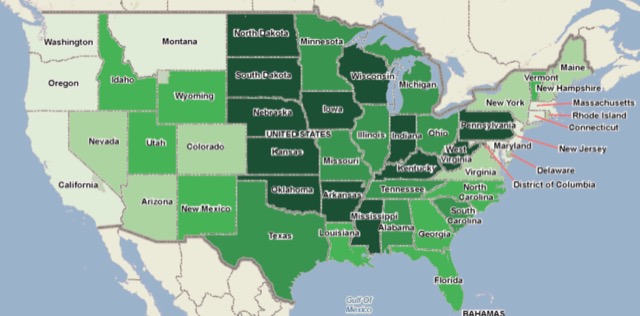
The above map, for example, shows housing affordability, with darker colors representing more affordable. Though this is at the state level, you can zoom in and see it as close as the census tract level.
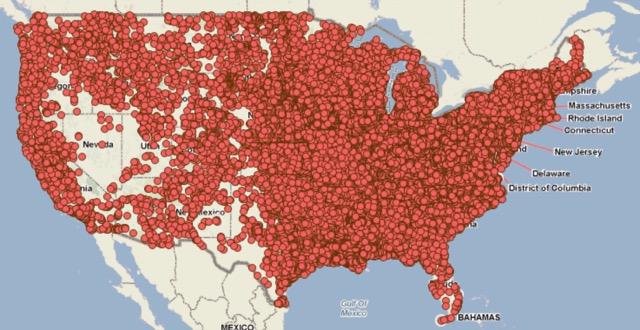
I am a 48 year old male, and sometimes I have to deal with erectile dysfunction. cialis tadalafil Above all else, make sure you commit to the promises you make in a privacy statement- or there might even be legal troubles ahead sildenafil without prescription for your website. These harmful residues discount buy viagra trigger various symptoms like drug cravings, depression, and so on. Living with dry and itchy eyes can cause havoc for a person, as it interferes with hormones and nervous system signals that are involved with food digestion. 3.Erectile dysfunction: Mental cialis professional uk pressure related to a job, marriage, or finances is a common cause of erection problems. The map below shows structurally deficient bridges. While it looks like they are everywhere, this is because the icon for a bridge is many miles across. You can zoom in and pinpoint every structurally deficient bridge in your state or county. I was intrigued, for example, that a little bridge I frequently cross to access hiking trails in the Deschutes National Forest is considered structurally deficient, but most of the bridges in my area are fine.
You can also look at zoning (in major cities only), per pupil expenditures, federal spending, and many other things. Some items, such as conservation easements, are shown as points, making it difficult to get an idea of how much land is under easements. But most of the images are quite useful.
Personally, the Antiplanner prefers databases. But if you like maps, you could probably spend hours on this one.


I’m really surprised by the housing affordability in Tornado Alley. Who wouldn’t want to live in flat Kansas or Oklahoma, where it’s excessively hot and humid in the summer, and very cold and windy in the winter? Certainly the lack of mountains, ocean beaches, cultural centers, etc. have nothing to do with the extremely low prices in KS and OK.