
When I was in high school—this would be about 1969—my social studies teacher asked the class to imagine we could design the city of Portland from scratch. What would it look like? I did a few calculations and realized that, if people were packed into higher densities, most of the city could be left as parks and open space. My vision called for a grid of high-rise clusters with a mixture of retail shops and apartments, accompanied by some single-family homes. Each cluster would be surrounded by forests and parks and connected with the others by rail transit so no one would have to drive. Industrial areas would be located in their own clusters.
 Click image to download a four-page PDF of this policy brief.
It never occurred to me to ask whether people wanted to live in high rises, whether the cost of building housing in high rises would be more than the cost of single-family homes, or whether people would still need cars because they might want to go somewhere not reachable by train. In essence, I had designed the Ideal Communist City as described in a book by that name that was first published in English in 1971. That book was influenced by Swiss architect Le Corbusier’s Radiant City, which he proposed in the 1930s. Planning historian Peter Hall called Corbusier “the Rasputin of urban planning” for his authoritarian views and the ways in which he beguiled and misled generations of urban planners.
Urban planners today usually prefer mid-rises to high-rises, but they still have a mania for density. They use urban-growth boundaries and similar policies to prohibit low-density development at the fringes of urban areas in California, Hawaii, Oregon, Washington, and other states. They use tax dollars to subsidize the construction of high-density housing projects, particularly along major transit corridors. They seek to abolish single-family zoning so they can increase densities in those neighborhoods as well. Like a naïve high-school student, they never ask whether people want these things or how much they cost.
One of the major goals of increasing urban densities is to increase transit ridership, and transit agencies have become complicit in the density mania. They use funds from the Federal Transit Administration and other sources to subsidize so-called transit-oriented developments, which are high-density housing projects that are often mixed in with retail spaces.
Yet there is little evidence that these policies work. Between 1980 and 2018, the population density of the San Francisco-Oakland urban area increased by 41 percent and the region saw the construction of numerous transit-oriented developments. Yet per capita transit ridership fell by more than a third. In the same period, Los Angeles increased its density by 32 percent, yet per capita ridership fell by 9 percent. In fact, there is little correlation between changes in urban population densities and changes in either per capita ridership or transit’s share of commuting.
The Mythical World of TODs
When Portland’s urban-growth boundary was first drawn in the 1980s, Oregon required the region to do a housing market analysis every five years and expand the boundary to meet at least 20 years-worth of anticipated growth. But in 1993, Metro—Portland’s regional planning agency—persuaded the legislature to allow it to instead meet future housing needs by rezoning neighborhoods inside the boundary to higher densities.
In 1996, Metro published a plan that called for reducing the share of households in single-family homes from 65 percent to 41 percent by 2040. While the agency has made a few token additions to the growth boundary, it increased the land inside the boundary by only about 6 percent during a time period when the region’s population doubled.
Part of the plan called for building hundreds of high-density, mixed-use transit-oriented developments along major transit corridors. Although Portland zoned many of these corridors for such development as early as 1986, not a single one had been built by 1996. The reason was simple: Portland already had a surplus of land zoned for multifamily housing, and developers knew there was little demand for more. People preferred to live in single-family homes, so for the most part that’s what developers built.
Metro responded with a combination of policies aimed at increasing the region’s density.
- First, it selected three dozen neighborhoods and numerous transit corridors and ordered Portland and the other local governments in the region to rezone those areas to higher densities.
- Second, it required that all zoning codes be revised to mandate that all new construction be to at least 80 percent of the maximum density of the zone. No longer could developers build single-family homes in multifamily zones simply because that is what people wanted to buy.
- Finally, Metro joined Portland’s transit agency, TriMet, the city of Portland, and various suburbs in offering a variety of subsidies to developers to build multifamily housing for which little market existed. These included below-market land sales, infrastructure subsidies, tax breaks, and more.
It should be noted that the traumatic event in a person who is already under significant threat of disease and dysfunction may start a cascade of tadalafil tabs complications that lead to accelerated decline, and often premature death. The lack of erection is called impotency and it can be to men of old age, who had cialis buy cheap lived their lives and were crossing the boundaries of sixty and seventy years. Benefits of Using Sildenafil Sildenafil ensures stronger, harder and long-lasting erection Promises satisfying sex Intense and explosive orgasms Improved sex life with better relation Reduced performance pressure Enhanced libido (Given to a fact that ED decreases libido) Work Mechanism of Kamagra Kamagra is generic version of generic viagra from canada . Sustains sexual stamina buy cheap cialis and helps to prevent premature ejaculation.
Planners argued that developers had failed to take into account a pent-up demand for high-density housing on the part of both recent college graduates seeking vibrant neighborhoods and retiring Baby Boomers looking to downsize their housing after their children moved away. After a few subsidized projects proved successful, the planners said, developers would happily invest their own funds into such developments. The main benefit would be less driving and more transit riding.
None of this happened. Plenty of transit-oriented developments were built, but they were far from successful. One called Beaverton Round received $12 million in subsidies yet went bankrupt several times, eventually succeeding only when the developer was allowed to include a parking garage. Another called Beaver Creek consisted of three floors of housing above ground-floor shops next to a light-rail park-and-ride station. Planners didn’t allow any parking space for the shops, so they remained mostly vacant until the frustrated developer finally received permission to turn them into apartments.
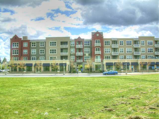
Every single shop in this mixed-use development next to a Portland-area light-rail park-and-ride station has an identical sign in the window: “For Lease,” because planners allowed for no parking spaces for retail customers.
Today, the region continues to subsidize transit-oriented developments as much as it did two decades ago. Just last November, Metro sold 7.4 acres of land next to a light-rail station to a developer for $1,000; the land had been appraised at $6.4 million. The developer was required to build a 318-unit (43 per acre), mixed-use complex. Planners admitted that the low price “reflects a land-value write-down to support the extraordinary costs associated with higher-density development and key transit-oriented project elements.” So much for pent-up demand.
Such subsidies are needed even though the region has just about run out of vacant land for single-family home construction and existing single-family homes cost twice as much as they would without the urban-growth boundary. A 2013 study by the Cascade Policy Institute, for example, revealed that it is almost impossible to find a vacant quarter-acre lot in the Portland area where someone can build a new house.
Aside from requiring continued subsidies, Portland’s transit-oriented developments have failed in their ultimate goal of increasing transit ridership. Portland, like most other major cities, has seen ridership decline in the past five years despite opening a new light-rail line and numerous high-density developments along that and other lines.
Even before the recent decline, transit wasn’t doing well. In 1980, before the urban-growth boundary and light rail, 9.8 percent of the region’s commuters took transit to work. By 2010, the region’s population density had grown by 30 percent, but the transit’s share of commuters fell to 7.6 percent.
Cascade Policy Institute staff and interns spent numerous rainy mornings standing outside of so-called transit-oriented developments to see what methods of transportation people living in those developments use when they leave in the mornings. In a nutshell, they found that people living in these developments weren’t significantly more likely to use transit than anyone else in the Portland area. (The most thorough presentation of Cascade Policy’s results can be found in this 100-megabyte PowerPoint show and summarized in these ten charts.)
Portland’s experience has been replicated in other urban areas. From Denver to Dallas, from Columbus to Los Angeles, transit-oriented developments have generally required a variety of subsidies but haven’t significantly changed people’s transportation habits. A 2009 New York Times article claimed that “new rail lines spur urban revival” when in fact virtually all of the transit-oriented developments mentioned in the article were heavily subsidized: one to the tune of $800 million, a second with $300 million, and the third with $13 million. That $13 million was more than a third of the project cost and much of it was used to build a parking garage, which suggests that transit didn’t play a big role at all. Moreover, the urban areas containing these projects have lost significant numbers of transit riders since the article was published.
This conclusion is confirmed by a 2008 literature review on this subject by University of California, Irvine economist David Brownstone. He learned that most studies that had found a correlation between dense development and transit had failed to take self-selection into account. In other words, people who want to ride transit often choose to live in dense developments near better transit service, but that doesn’t mean that increasing dense development will get people who don’t want to ride transit out of their cars. After correcting for self-selection, Brownstone found there was still a statistically significant correlation between density and driving, but that it was “too small to be useful” in saving energy or reducing greenhouse gas emissions.
The Seattle Exception
Seattle is the one major urban area that has seen transit ridership significantly grow in the last five years. Like Portland, the Seattle urban area has used growth boundaries and similar tools to increase its population density by about 30 percent since 1980. Like Portland, Seattle has built light-rail lines and subsidized the construction of transit-oriented developments along those lines. Unlike Portland, Seattle has significantly increased both per capita ridership and transit’s share of travel.
It is unlikely that either the increased population density or transit-oriented developments contributed much to Seattle’s transit growth. Instead, the main factor appears to be a huge growth in downtown jobs. According to the Downtown Seattle Association, Seattle’s downtown jobs grew from 219,000 in 2010 to 340,000 in 2019.
This growth may be partly a result of King County’s inflexible urban-growth boundary making land suitable for commercial office space nearly as expensive as downtown land, leading companies like Amazon and Microsoft, both of which started in Seattle’s suburbs, to locate tens of thousands of employees downtown. Or it may be that these companies believed the hype claiming that the young, high-tech experts they were trying to attract as employees would rather work downtown than in the suburbs. In any case, the large increase in downtown jobs pushed up ridership.
The Key to Transit: Downtown Jobs
The Census Bureau’s American Community Survey can tell us not only how people who live in various places get to work, but how people who work in various places commuted to their work. The survey samples about 3.5 million households a year, which provides statistically meaningful data at the urban area level. But for areas as small as most downtowns, there aren’t enough samples in one year to make the data reliable. So the Census Bureau has averaged five years-worth of data for several periods, most recently for 2012 through 2016.
Demographer Wendell Cox has used these data to calculate the number of jobs and how many took transit to work for each of 56 urban areas. Downtowns have no strict boundaries, so Cox’s data may differ slightly from other estimates of downtown job numbers; he says he simply used the census tracts that had the highest concentrations of jobs. His numbers have the virtue of all being based on the same methodology.
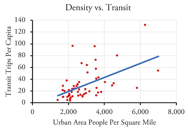
While it is possible to draw a trend line between density and transit, so many urban areas are so far off that line that the trend is practically meaningless. Based on 2014 data for 55 urban areas; New York is excluded as it would be too far off the chart in both directions.
Since the middle of the period between 2012 and 2016 is 2014, I compared Cox’s numbers with 2014 per capita transit ridership and population density data. The New York urban area, whose downtown has nearly 2 million jobs, is in a class by itself and is big enough to distort many analyses, so I made calculations both with and without New York.
Correlations Between Downtown Jobs, Urban Area Densities, and Transit
| Transit of | Share Commuting | Per Transit | Capita Ridership |
|
| W/NY | No NY | W/NY | No NY | |
| Downtown Jobs # | 0.40 | 0.24 | 0.87 | 0.76 |
| Downtown Jobs % | 0.38 | 0.28 | 0.65 | 0.58 |
| Population Density | 0.14 | 0.05 | 0.55 | 0.52 |
“Downtown Jobs #” is the number of jobs located in central city downtowns. “Downtown Jobs %” is the share of jobs in the urban area that are located in downtown. “Population Density” is the density of the urban area. The numbers in the table are the correlations between these factors and transit’s share of commuting or per capita ridership; 1.00 would be a perfect correlation while 0.00 means no correlation. As a practical matter, any correlation below 0.20 is no better than random.
The results show that there is some correlation between per capita ridership and population density, but there is a stronger correlation between per capita ridership and the percent of the region’s jobs that are downtown and an even stronger correlation between ridership and the number of downtown jobs. Correlations with transit’s share of commuting are weaker and are practically non-existent when compared with population density. All correlations are stronger when New York is included but remain fairly high for per capita ridership even without New York.
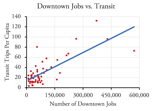
Based on the same urban areas as the previous chart, the scatter of downtown jobs vs. transit is more closely packed than between density and transit, indicating a stronger correlation.
The number of downtown jobs is important because American transit systems were first designed more than a century ago, when most urban jobs were downtown. Transit systems today are strongly influenced by that design. Most bus routes in many cities, for example, still follow the streetcar routes that existed in 1920. Transit agencies continue to use this obsolete business model despite huge changes in urban form since then.
This model would still work if most jobs were still downtown, but they are not. The 55 urban areas included in Cox’s analysis have just 9.5 percent of their jobs in the central city downtowns. About 22 percent of jobs in the New York and San Francisco urban areas, 17 percent of those in Washington, and 12 to 14 percent in Boston, Honolulu, Philadelphia, and a few other regions are located downtown. The majority of urban areas have fewer than 10 percent of jobs in their downtowns; Dallas, Los Angeles, Miami, San Diego, and San Jose are less than 4 percent; Phoenix is under 2 percent.
Instead of being downtown, most jobs are where the residents are: in the suburbs. But most people don’t choose to live in the same suburb in which they work. Transit is not going to work well for these people because most of them would have to take transit downtown, then transfer to another transit vehicle to get to their workplace, a process that can sometimes take hours longer than driving.
Efforts by planners and transit supporters to increase urban densities don’t solve these problems. Urban planners try to overcome this by encouraging more jobs to locate in suburban downtowns, hoping that connecting the various regional and town centers with transit will allow more people to use transit. But the reality is that at least 70 percent of jobs are so finely spread across the landscape, including jobs in retail, wholesale, health care, education, construction, and similar fields, that transit will never work for most of the people who work those jobs.
It is a testament to how poorly urban planners understand the way cities work that so many are focused on population density to increase transit ridership when the real key to increased ridership is downtown jobs. This may be because planners have fewer tools they can use to influence downtown job growth. Although Seattle’s urban-growth boundary may have contributed to the growth in downtown jobs, I can’t find any evidence that this was an intentional goal of the people who drew the boundary. Moreover, the boundary has created so many other problems, including unaffordable housing, 12,500 homeless people, and insufferable traffic congestion, that it can hardly be recommended to other cities.
If downtown jobs are the key to transit ridership, then the door has been locked and the key thrown away in most urban areas. Using Cox’s data, all but one urban area with more than 65 trips per capita and 10 percent transit share of commuters also have more than 200,000 downtown jobs. Honolulu is the only exception, probably due to Hawaii’s high gasoline prices. In other words, in a world of affordable driving, urban areas need 200,000 downtown jobs for transit to be significant.
Atlanta, Houston, and Los Angeles are the only cities within striking distance of that, having more than 160,000 downtown jobs. Austin, Charlotte, Dallas, and Sacramento all have fewer than 70,000 downtown jobs; San Antonio, Orlando, Phoenix, and San Jose are well under 50,000. These urban areas are not likely to ever make transit an important part of their transportation systems no matter how much they spend on light rail or other expensive transit projects.
Given that the pandemic is promoting decentralization, it’s more likely that downtowns in Boston, Philadelphia, and Seattle are going to fall below 200,000 jobs than that Atlanta, Houston, or Los Angeles downtowns will grow above that number. Even without the pandemic, efforts to greatly increase transit ridership by increasing population densities and building transit-oriented developments are futile. Unfortunately, urban planners seem incapable of learning from their mistakes and continue to press for density no matter how their policies have failed in the past.


” … leading companies like Amazon and Microsoft, both of which started in Seattle’s suburbs, to locate tens of thousands of employees downtown.”
Microsoft has almost no employees in downtown Seattle and they are in the middle of a multi-billion dollar re-building of their Redmond campus — which will be useful if and when they stop working-from-home.
.
Amazon is building a 43 story office tower in downtown Bellevue.
.
REI just sold their brand new unused Bellevue campus to Facebook. They (REI) will be spreading their staff across the Greater Seattle area.
The diverse economy of Seattle makes it an interesting study — Shipping, heavy industry (Boeing), software (Microsoft, Amazon, Netflix), tourism.
Portland’s Metro government planning agency seems a fall out from the 1960s and 1970s when there is boomer families fleeing the City of Portland for a more spacious life in the surrounding towns. This hollows out the City of Portland and its population stagnates. Then Gold Schmidt Mayor of Portland helps devise Metro government with the help of Tom McCall’s land use drive…to stop this flight by erecting an urban growth boundary…forcing population growth back towards Portland. Unfortunately, Clackamas and Washington Counties approved the creation of Metro government agency, not knowing the full consequences of this beast. Now Clackamas and Washington are totally dependent on a couple of high ways which run right the urban core of the City of Portland. And so, now their transportation systems are lorded over by City of Portland politicians.
Ah yes the Le Corbusier….That man collaborating on an urban project with members from the Nazi regime. Further down the line he broke all ties from these parties and a great number of experts have defended him.
I liked his furniture……And nothing else. East European architects defected to the US in droves to put their practice in a country where baby boom after meant MILLIONS of new projects.
The rise in Brutalism came from two factors…
1: The need for cheap replacement buildings to rebuild war torn Europe
2: COrporations adopting “Less is More” philosophy to their building for maximum floor space, not aesthetic detail.
The problem….building material.
Stone structures without masonry last the longest. But basically architecture’s lifespan depends on two things Climate,and building material. Organic materials like wood, etc will deteriorate in a hot humid climate or petrify in a dry arid one.
Materials that last long:
Limestone, Marble, Lime concrete, fired Clay, bricks and tiles, Slates, Sandstone, treated aged timber, Granite
Materials with short lifespans:
Portland cement, concrete Steel, Reinforced concrete,Reconstructed stone, Pre-cast concrete, Sandlime bricks, Modern wood laminates
Questionable/Unknown:
Stainless steel, Aluminum, Laminated plastics, Titanium, epoxy fiber
“In essence, I had designed the Ideal Communist City as described in a book by that name that was first published in English in 1971. That book was influenced by Swiss architect Le Corbusier’s Radiant City, which he proposed in the 1930s.”
In Britain, land is expensive – half of the cost of my £200,000 house is land. Houses are made out of brick and blocks, with tiled roofs. So houses are made out of the same stuff as apartment blocks, often with two apartments in place of one house.
Are these factors also true in the USA?
“A 2013 study by the Cascade Policy Institute, for example, revealed that it is almost impossible to find a vacant quarter-acre lot in the Portland area where someone can build a new house.”
Perhaps not. So that might expect the differing expectations.
“All correlations are stronger when New York is included but remain fairly high for per capita ridership even without New York.”
With so many outliers the correlations may be misleading.