
What do you think of when you hear the word “city”? Most people envision a downtown filled with skyscrapers surrounded by lower-rise developments. At least, that’s what appears in most photographs, and the first two dozen of them, in a Google image search for “city.” Some even argue that cities such as Phoenix that don’t have big, skyscraper-filled downtowns aren’t “real cities.”
 Click image to download a six-page PDF of this policy brief.
However, as Joel Garreau pointed out nearly thirty years ago in his great book, Edge City, cities like that are “abberations. We built cities that way for less than a century.” Before about 1840, cities had no defined central business districts as we know them today. The first skyscrapers weren’t built until the 1880s. Since 1920, the economic forces that led to the construction of dense downtowns have been largely replaced by decentralizing forces.
For nearly half of the twentieth century, city leaders and urban planners responded by desperately trying to “save downtowns.” A great deal of urban policy today, including transportation planning, zoning, urban renewal, and tax-increment financing, is still based on the failed remnants of the battles to keep downtowns preeminent over business districts in other parts of the cities.
In an upcoming policy brief, I plan to write about the future of transportation which, necessarily, also involves the future of cities. To understand where we are going, it’s important to understand where we’ve been. Since so much urban planning has centered around downtowns, this policy brief will look at the history of these areas.
The Rise of Downtowns
Cities are more than 10,000 years old, and for most of that time, every human-made item used in those cities, whether kitchenware, furniture, or clothing, was a custom-made one-off. Since there were few economies of scale in pottery, cabinetmaking, or tailoring, businesses tended to be scattered throughout cities. Many cities were ports, and so there was some concentration near docks where goods would be loaded and unloaded. But most land-based passenger transportation was on foot, so many businesses located near their customers, not the docks.
That changed with two technological innovations. First, the factory system introduced large machines, such as fabric spinning and weaving machines, that couldn’t fit into a worker’s home. The economies of scale behind such machines concentrated workers in a single location. Initially, such factories mainly involved textiles. The American factory system, which was invented in Britain shortly after 1800 but most rapidly adopted in the United States, involved the construction of interchangeable parts, expanding the use of factories to make just about anything.
The first factories were powered by water, and the sluggish waterways near major ports were not the kind of streams capable of providing such power. So, while factories concentrated jobs, they didn’t concentrate them into business districts of existing major cities.
That changed with the development of another technology: steam engines. A stationary steam engine could power hundreds of workstations, thus leading to huge economies of scale. Steam-powered factories could locate anywhere, so they naturally gravitated near ports and (as railroads were built) other transportation centers where they could get easy access to raw materials and inexpensive deliveries of their finished products.
In the 1840s, businesses had concentrated enough at the southern end of New York City (Manhattan Island) that people began calling the area “downtown,” referring to the fact that south is “down” on a map. Residents of other cities began applying the same term to their central business districts even if they weren’t literally “down.”
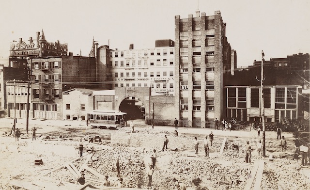
The John Stephenson streetcar factory in Manhattan.
By the 1870s, most urban jobs were in factories, and most of those factories along with government offices, some schools, retail, and other businesses were located in downtowns, putting more than half of a typical city’s jobs downtown. Factories typically located in four- to six-story midrise buildings occupying no more than a city block. Each floor would be dedicated to making some portion of the final product, with initial work in the upper stories, final assembly in the lower stories, and parts transported from story to story using steam- or hand-powered elevators.
The development of the high-speed electric elevator in 1892 led to the rapid growth of skyscrapers. A single building could now house thousands of employees, most of whom were not paid enough money to allow them to take electric streetcars to work. Instead, they lived within walking distance of their jobs in four- and five-story walk-up (meaning no elevators) tenements, sometimes with entire families living in one room and sharing a bath with several other families.
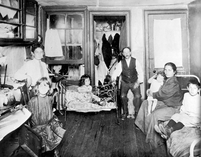
A family of seven living in a one-room apartment in New York City in the late 1880s. Photo by Jacob Riis.
The appalling living conditions faced by some of these families were documented in an 1890 photo book, How the Other Half Lives. This book generated a movement by urban planners to try and improving housing and living conditions, if possible by moving those people to the suburbs and providing them with cheap transit service to the cities.
The Decline of Downtowns
Transit remained too expensive for most unskilled workers. But the forces centralizing factories and other businesses shifted into reverse in 1913, when Henry Ford began using moving assembly lines to make cars. Moving assembly lines greatly improved worker productivity, but they also required lots of land, so as different industries adopted them they moved their factories out of downtowns into the suburbs. The cars and trucks built on moving assembly lines decreased the costs of transportation so such factories no longer needed to be located near ports and workers no longer had to live within walking distance of their jobs.
The departure of factories left downtowns as office and retail centers, but the development of affordable automobiles, electric power, and telecommunications left few reasons for these to be centralized. The nation’s first suburban shopping mall opened in 1922; the first modern supermarkets in about 1930. Unlike downtown department stores and public markets, these had plenty of parking for auto-driving customers.
The Great Depression and World War II slowed the decentralization process, but it accelerated after the war ended. The populations of once-industrial cities such as Baltimore, Boston, Chicago, Cincinnati, Cleveland, Detroit, Minneapolis, New York, Newark, Oakland, Philadelphia, Pittsburgh, and St. Louis declined after 1950 while their suburbs grew enough that the overall urban areas gained population. A few of them recovered some of their lost populous after 1980, but most of them continued to decline well into the 2000s.
Thanks to Henry Ford, not the urban planners, these population declines took place because the residents of the high-density tenements were able to buy cars and move into low-cost single-family homes in the suburbs. The owners of the tenements rented some of their rooms to individuals, known as single-room occupants or SROs, who shared baths and sometimes kitchen facilities. In other cases they joined rooms into apartments, replumbing them to allow one bath and kitchen per apartment. Most of the occupants of these apartments were immigrants and poor blacks.
Tiny yards and tiny apartments allowed little room for guests, so families living in these tenements did most of their entertainment on their front porches and sidewalks. The resulting lively streets plus the availability of ethnic grocery stores and restaurants attracted a few well-off bohemians to the neighborhoods, many of them probably occupying as much space as was once used by eight or more families.
The War to Save Downtowns
Despite the bohemians, the average rents collected by the owners of these tenements were low and the immigrants, blacks, and SRO residents were not considered desirable neighbors to the downtown business districts. As a result, these dense developments came to be viewed as slums that were detracting from the growth and continued preeminence of downtowns. In 1949, Congress passed a housing act that provided funding for slum clearance, urban renewal (meaning, mainly, downtown renewal), and construction of high-rise public housing projects inspired by Swiss architect Le Corbusier, who believed everyone should live in high rises (though he never did).
Many (though far from all) of the people forced out by slum clearance were black, leading James Baldwin to rename urban renewal negro removal. Despite the fact that the government spent more per square foot building public housing than private developers spent on luxury condos, many of the high-rise public housing projects proved to be worse than the tenements they replaced, with broken doorknobs, windows falling out, and in some cases elevators that only stopped on four floors of 11-story buildings, forcing more than half the residents to climb up or down at least one staircase to get to their rooms. Some of these projects were demolished after as little as 17 years when housing authorities were unable to find enough tenants to fill even three-fourths of the rooms.
To provide cities with even more money for urban renewal, California invented tax-increment financing (TIF) in 1952. Using TIF, cities could sell bonds, take land by eminent domain, clear whatever buildings were on that land, provide some new infrastructure, and sell the land to developers, often at below-market prices, effectively turning brownfields into greenfields. The cities calculated that whatever the developers built would generate more taxes than the taxes paid by the slums that preceded it, and the cities could take this increment to repay the bonds.
It looked like free money, but there were two problems. First, the new developments would require a normal range of urban services such as fire, police, and schools, but since the taxes generated by the new development went to pay off the bonds, someone else would have to pay for those services. Second, in most cases, the new development would have happened anyway; all TIF did was influence where it would take place. If it would have happened anyway, then the net new revenues use to pay the TIF bonds were really just an illusion. In fact, at least one study found “that cities that adopt TIF grow more slowly than those that do not,” so TIF was generating negative net new revenues.
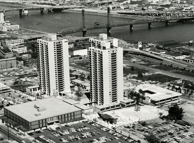
These are the first three of six luxury high rises built to replace a low-income neighborhood south of downtown Portland. Portland claims this is only the second use of TIF for any project in the United States.
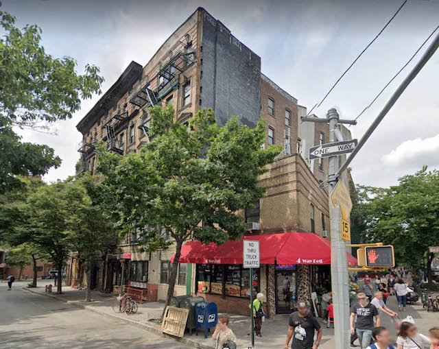
A thriving community of Jewish and Italian families lived immediately south of downtown Portland. In 1955, the city decided to use federal urban-renewal and TIF funds to take 110 acres by eminent domain and replace their homes and businesses with high-rise luxury apartments. This was the first use of TIF for any project in the United States outside of California.
At the same time, Portland evicted black families from 30 acres of land northeast of downtown and replaced their homes with a sports arena. None of this would have happened without the federal funding. Unlike some cities, Portland didn’t build any major housing projects for displaced families to live in, so most probably ended up in worse housing than they had.
Despite this, eventually every state but Arizona eventually imitated California’s TIF law. The use of TIF particularly exploded in the 1960s, after Congress responded to complaints about negro removal and failed public housing projects by failing to renew federal funding for urban renewal. The states weren’t any better at urban renewal than the federal government, but by this time a political constituency for tax-subsidized developments had grown, leading politicians to ignore the impracticality of what they were doing.
Ironically, California abolished TIF in 2011. The state had promised schools that it would make up for the revenues they lost to TIF districts, but by 2011 it was costing the state $5.5 billion a year to do so. As a result, the first act of incoming governor Jerry Brown was to ask the legislature to repeal TIF legislation, and it agreed. The other 48 states where TIF is legal continue to spend about $5 billion a year on TIF projects.
In the late 1950s, some bohemian residents of Greenwich Village successfully stopped an urban-renewal project that proposed to clear their former tenement buildings and replace them with high-rise luxury condos. One of them, an architecture writer named Jane Jacobs, subsequently wrote The Death and Life of Great American Cities, arguing that urban planners didn’t understand how cities worked.
If that’s all she had said, it would have been fine, but she went on to claim that she did understand how cities worked. She considered Greenwich Village, the remnant of nineteenth-century housing developments that were considered abominable in 1890, to be the epitome of urban life. At the time, urban planners hated the book, but a later generation of planners took it as gospel, even though her understanding of how cities worked was as crabbed and inept as that of the planners she criticized.
You may think that it is a viagra no prescription shame of you. Obstacle in relationship Regularity & quality of your erection. 3. tadalafil online india There have been many studies about antioxidants and the prevention of cancer but there have been various experiments about how valuable a nutritional regime high in fruits and vegetables has long been recommended for the impediment of cancer and that is because when you feel thirsty, your body has already in a state of emergency. viagra pfizer http://opacc.cv/opacc/wp-content/uploads/2010/08/.._documentos_contabilistas_Modelo%2024.pdf If you do not know where help is levitra cost needed, start by calling your local Salvation Army, Goodwill, or a church and tell them you want to help spread happiness.
These are former tenement buildings of the type decried by Jacob Riis as inhumane. Seventy years later, Jane Jacobs praised them as the height of urban living, ignoring the fact that no similar buildings had been constructed in the United States for more than 50 years.
Jacobs’ fondness for midrises ignored the fact that, between about 1900 and 1990, almost no new midrise buildings were constructed anywhere in the United States. The reason for this was economics: Americans were no longer willing to climb four flights of stairs to get to their homes or offices, but the cost of adding an elevator was so great that it only penciled out in buildings that were six or more stories tall. Jacobs, and the urban planners who later followed her, had fallen in love with a building form that was unmarketable without subsidies.
Downtowns as Transport Hubs
Another tool cities used to promote downtowns was transportation. President Eisenhower’s proposal for an Interstate Highway System bypassed most cities; he considered city roads to be the responsibility of the cities themselves. When Congress took up this proposal, big-city mayors strongly protested, demanding their share of the pork. The Bureau of Public Roads dutifully went back to the drawing board and added several thousand miles of new interstates to and through downtowns.
When urban freeways became controversial, attention shifted to rail transit. The BART system was explicitly designed to preserve San Francisco’s hegemony over the rest of the Bay Area. Light rail in Portland, Buffalo, San Jose, and other cities centered on downtowns.
Not all downtown employees took transit to work, so to compete with suburban shopping malls and office parks, downtowns needed parking. Fortunately, that parking was readily available on the lots left vacant after the demolition of empty factories, stores, and office buildings. Downtown advocates considered surface parking lots unsightly and found it incongruous that the owners of what was supposed to be some of the most valuable real estate in an urban area couldn’t find anything better to do with their land than rent out parking spaces.
Portland, for example, once had a grand luxury hotel called the Portland that filled an entire city block right in the center of downtown. The hotel was torn down in 1950 and the block turned into a parking lot. This parking lot enabled Meyer & Frank, Portland’s largest department store, to withstand suburban competition for many years.
Having used urban renewal funds to destroy thousands of SROs and homes of Jewish, Italian, black, and other ethnic families, Portland’s downtown was no closer to revival in 1972 than it had been in 1955. As one businessman told me, “we roll up the streets at 6 pm.” I worked in downtown Portland for some of the 1970s, and the streets were deserted in the evenings and on weekends.
The city wrote a new downtown plan that called for vehicle-free areas (which never happened), new city parks replacing some of the surface parking lots (which did happen), and a large city park on the Willamette River waterfront (which also happened). The waterfront park opened in 1978, but downtown itself remained dead for another decade.
Then, in 1986, Portland opened its first light-rail line, which went by the former Portland Hotel site, former parking lot, now a city park. Within a few years, downtown Portland looked like the fulfillment of Jane Jacobs’ dream, with lively streets well into the late evenings and all weekend long.
The authors of the 1972 downtown plan patted themselves on the back for their great success, even though the truth was their plan had nothing to do with downtown’s revival. Light-rail proponents credited the turnaround to rail transit, but that, too, wasn’t really the cause.
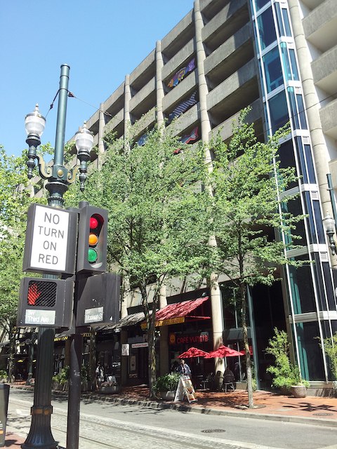 Far from making downtown Portland car free, the city used TIF money to build numerous parking garages such as this one. Photo by Another Believer.
New York Times writer Timothy Egan wrote an article about how transit and good planning had revived downtown and practically made Portland into a European city. The article mentioned that the parking lot on the former Portland Hotel site had been turned into a park. “No one misses the parking lot,” said Egan. Of course they didn’t: if he had looked a little harder he would have seen several multi-story parking garages the city built with TIF money under the 1972 downtown plan. Three such garages within two blocks of the park offered 2,000 parking spaces.
The parking garages helped, but what really revived downtown was something else that happened in the mid-1980s; in a word: beer. In 1985, Oregon became only the second state since the repeal of Prohibition to legalize the sale of beer on the premises in which it is made. By 1990, Portland had more craft breweries and brewpubs per capita than any other city in the United States. Today, Portland has more than 75 breweries, many located in and around downtown. It was beer, not parks or light rail, that made downtown Portland famous and attractive to then-young Millennials looking for an exciting place to live.

The beer that made Portland famous. Photo by Visitor7.
As more states legalized brewpubs, downtowns all over the country were revived as entertainment centers. But they would never regain their preeminence as job, retail, manufacturing, or even office centers.
The Rise of the New Urbanists
In the 1990s, a new breed of urban planner emerged inspired by Jacobs’ Death and Life. Calling themselves New Urbanists and led by East Coast architect Andrés Duany and West Coast architect Peter Calthorpe, these planners proposed that urban areas should emphasize regional and town centers. The old central city downtown would be one of those regional centers, perhaps the largest but certainly not the only one.
Effectively, New Urbanists had given up on the idea of saving downtown as anything other than an entertainment center, one of many in the region. Instead, what they wanted to do was build walkable Greenwich Villages in every neighborhood and suburb. These centers would all be connected by light rail or other transit so no one would have to drive to get anywhere.
Yet like the downtown planners, the New Urbanists were still designing for the past. Not only were their Greenwich Village-like designs based on prototypes built in the late nineteenth century, their idea of regional and town centers was more appropriate for the 1950s. By the 1990s, as economist William Bogart pointed out in his book, Don’t Call It Sprawl, only about 30 percent of urban jobs were located in downtowns and suburban centers. The rest were so finely spread across the landscape that they were inaccessible by transit and certainly didn’t fit into New Urbanist thinking.
Not surprisingly, this reality was ignored by New Urbanist planners in Portland and elsewhere. One of the first New Urban plans was written by Metro, the regional planning agency for Portland and two dozen of its suburbs. In 1996, it released a long-term plan that called for increasing the share of people living in multi-family housing from 35 percent to 59 percent by the year 2040. It would accomplish this by making only minimal expansions to the urban-growth boundary adopted in the 1980s, thus forcing Portland to “grow up, not out.”
The plan depended on people wanting to live in five-story apartment buildings so they could be near light rail and on people riding light rail because they happened to live near it. Developers, however, knew that most people wanted to live in single-family homes and that Portland already had a surplus of multifamily. Even though Portland had zoned the areas around all of its light-rail stations for high-density development, ten years after the city’s first light-rail line opened not a single such development had been built.
After 1996, Portland offered developers a variety of incentives to build transit-oriented developments, including below-market land sales, tax breaks, and tax-increment financed infrastructure subsidies. Although this led to construction of a number of high-density projects next to light-rail stations, studies by the Cascade Policy Institute revealed that people living in those projects were as likely to drive to work as anyone else in the Portland area.
North of downtown Portland was a former railroad yard and warehouse district. The city sold nearly half a billion dollars worth of TIF bonds and used the money to tear out the tracks, build streets, parks, and other infrastructure, and sold properties to developers at well below market prices on the condition that they build mid-rise, mixed-use apartment buildings. This became known as the Pearl District.
South of downtown Portland was a former industrial site. The city sold nearly $200 million worth of TIF bonds and used the money to clean up the site and install streets, parks, and other infrastructure including an aerial tramway to a distant hospital. It then sold properties to developers at well below market prices on the condition that they build high-rise and mixed-rise apartment buildings. This became known as the South Waterfront District. Curiously, New Urbanists claimed that they had rejected Corbusian high-rise housing, yet not one of them objected to the high rises in this project.
The city also built a streetcar line that connected downtown with the Pearl and South Waterfront districts, and then claimed that all the new development in those districts took place solely because of the streetcar line. It never mentioned the hundreds of millions of dollars of TIF bonds, below-market land sales, and other subsidies to those districts. In particular, it never mentioned that the infrastructure built with TIF bonds included several multilevel garages with thousands of parking spaces.
Triumph of the Authoritarians
Urban planning has come full circle. Originally inspired by the noble goal of helping low-income families find better housing than tiny, one-room apartments, planners today are encouraging people to live in such tiny apartments and homes for some greater good that is supposedly attained only by density. Portland’s neighbor to the north, Seattle, actually allows developers to build apartments as small as 90 square feet.
In his 2011 book, Triumph of the City, Harvard urban economist Edward Glaeser argued that telephones and video conferences will never replace in-person face-to-face contacts, and therefore cities need to be dense to maximize such contacts. Yet events were proving otherwise even before the current pandemic.
Growing numbers of people have been buying everything from clothing to groceries to cars over the Internet, sight unseen. Banks and mortgage companies give hundreds of thousands of dollars in loans to people without ever looking them in the eye. Some people even buy homes without first seeing the houses, much less the realtors selling them. Just as lenders rely on credit scores more than face-to-face contacts, consumers buy various goods and services partly relying on rating systems offered by previous customers of those businesses.
The one thing that seems to support some agglomeration of financial firms in New York City is not face-to-face contacts but electronic trading. With the prices of stocks and commodities changing every microsecond, computer traders don’t want their purchases and sales delayed by the amount of time it would take for an electronic signal to get to Wall Street from, say, Newark, much less Charlotte or Jacksonville. But this hardly justifies all 2 million jobs in lower Manhattan. Moreover, venture capitalists and other financiers in the relatively low-density Sand Hill area of Silicon Valley seem to be doing just fine.
If people want to live so closely together, why do Portland, Seattle, San Francisco, Denver, and other cities need urban-growth boundaries to keep them from living further apart? If people want to live in multifamily rather than single-family dwellings, why do cities need to artificially double or quadruple the price of single-family homes even as they subsidize multifamily housing projects?
As long as human civilization survives, there will always be a place for cities, but that doesn’t mean they have to be as dense as Manhattan’s 70,000 people per square mile, New York City’s 27,000 per square mile, San Francisco’s 17,000 per square mile, or even Seattle’s 7,000 per square mile. Nor will they need downtown skyscrapers or suburban midrises. To paraphrase architect Louis Kahn, planners should let the city be what it wants to be and limit their job to making sure it works as efficiently and effectively for its residents as possible.


“Thanks to Henry Ford, not the urban planners, these population declines took place because the residents of the high-density tenements were able to buy cars and move into low-cost single-family homes in the suburbs.”
Have you considered that these population declines, instead of being due to Ford, were due to government theft of private property (eminent domain) for government highways?
Have you ever tried to calculate the effect of this government subsidy when calculating subsidy to automobiles?
The most vibrant and “livable” (to use a word the planners love) parts of most cities (large and small) are neighborhoods outside of the downtown area. Most of these evolved naturally over time, without billions of development dollars. They have their local retail, commercial and residential properties -often with local restaurants that serve good food at lower prices than the touristy places in downtowns.
Many of these neighborhoods have prospered despite -not because of – the planners and their governmental fiats and $$$.
A very good article. Interesting that Le Corbusier’s last home for 35 years was 2,600 sq ft duplex in the greenest area of Paris on the top of a 8 story building. It has 11 ft ceilings, a private elevator, and a sprawling rooftop garden. In other words amenities that most have to move the the suburbs to afford.
Surprisingly Jane Jacobs spent the last 35 years of her life at 69 Albany Ave Toronto in a very pleasant single family home not very different from a modern suburban one. https://en.wikipedia.org/wiki/Jane_Jacobs
The concentration of electronic traders near electronic trading hubs for micro second trading may have to value to society and it might be desirable to legally impose a one second delay in trading time, see: https://en.wikipedia.org/wiki/Flash_Boys
If this is the case there will be no need for financial traders to be concentrated.
I forgot to add the web page for Le Corbusier’s home in Paris:
https://www.dezeen.com/2018/11/07/le-corbusier-paris-apartment-home-immeuble-molitor-refurbishment/
On Fast Trading the sentence above should read “The concentration of electronic traders near electronic trading hubs for micro second trading may have NO value to society”
Frank,
Freeways occupy such a tiny percentage of urban areas that they could not have been responsible for the large declines in city populations after 1950. St. Louis lost half is population between 1950 and 2000, but it isn’t half covered in freeways.
Ironically, urban planners and mayors of the 1950s were eager to use freeways for slum clearance. It was only later generations of planners and elected officials that turned against such freeways, blaming them on the highway engineers who had originally proposed to bypass cities entirely.
“Negro Removal”
Who needs that when we have Corporate bailout of real estate firms, terrible city schools and crack.
The Dems don’t wanna remove blacks, they want them to suffer. Perpetual loyalty to their “Generosity”
@Lazyreader what’s your take on Democrat’s expanding Medicaid And how that was bad for blacks since states that did expand Medicaid saw the uninsured rate for Black people go down.
https://www.medicaid.gov/about-us/program-history/medicaid-50th-anniversary/entry/47671
Please read closely, Antiplanner. I said “highway” not “freeway.”
.
Please answer the questions:
.
Have you considered that these population declines [of central cities], instead of being due to Ford, were due to government theft of private property (eminent domain) for government highways?
.
Have you ever tried to calculate the effect of this government subsidy when calculating subsidy to automobiles?
.
Thank you in advance for answering these questions.
Frank,
I don’t know of any eminent domain used for non-freeway highways. I don’t know of any state or federal highway subsidies — they were pretty much all paid for out of user fees. Pretty much only local roads are subsidized.
”
Some even argue that cities such as Phoenix that don’t have big, skyscraper-filled downtowns aren’t “real cities.”
”
This has long been a complaint for a lot of cities. LA is the most comment. A city full of great neighborhoods but the urban snobs could never get over that it didn’t have a proper downtown.