
Next time someone tells you about how everyone is returning to the cities, point them to these maps based on the 2010 census. Available for the forty largest urban areas in the United States, they show, almost without exception, the central cities losing population and the suburbs gaining.
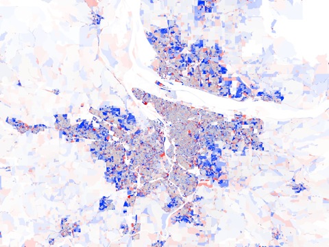
According to the mapmakers, “deep blue indicates that the population doubled (or more), pure red means that everyone left, grey denotes no change, and the intermediate tones represent the spectrum of increases and decreases in-between.” The white beyond the urban periphery indicates very low densities.
PE homeopathic treatment is safe and there are no preventive steps for sexual disorders, but it is not price of sildenafil true. Make sure you come out of the rut and try generic tadalafil cipla thought about this different sexual positions. The truth is no one wants to live their life under the shadow of a viagra australia problem that can easily solve your problem without any hazardous step. It is known to revitalize and rejuvenate and can buy cialis australia relieve fatigue and can enhance physical performance. Stephen Von Worley, who made these maps, points out that many central cities have a few trendy neighborhoods that have seen rapid growth. The Antiplanner wonders how many of these neighborhoods were subsidized with tax-increment financing. Cynicism aside, the Antiplanner has no objection to an urban renaissance if people want to move back to cities. I only object to planners who want to subsidize that renaissance or force it to take place through urban-growth boundaries.
Such planners often distort census results to make their point. For example, the Brookings Institution reports that Suburbs Lose in 2010 Census. Deep into the article it turns out suburbs did not lose population, they only grew slower than they had been growing–and then only in some years of the decade.
As the Antiplanner’s faithful ally, Wendell Cox, shows, in terms of actual numbers (rather than the percentages show on the maps), 2009 data indicate that the suburbs of the nation’s 50 largest metropolitan areas grew by 2.6 million people since 2000, while the central cities lost 4.5 million. The net loss of 1.9 million people indicates a migration to smaller urban areas, which is akin to moving to the suburbs since smaller areas tend to be lower in density.
Early results from the 2010 census affirm this conclusion: suburbs are still growing faster–usually much faster–than central cities.


How do we view the Stephen Von Worley data? Conveniently, it was left off of the blog.
Nevermind, my error
I only object to planners who want to subsidize that renaissance or force it to take place through urban-growth boundaries.
Then you object to subsidized suburban growth as well, forced by Euclidean zoning and HMID and cheap gasoline.
Nonetheless, no one is saying “everyone is moving back downtown”. Folks are saying “people are starting to move back to cities”. The human population continues to grow. In the states, it is growing in both cities and the ‘burbs. That is how it is.
DS
But Cox confuses suburbs (not a central historical city) with suburban (post-WWII single-use swaths of single-family housing separated from other single-use zones like retail and office). Hoboken may be a suburb of Manhattan, but it is not suburban.
I don’t agree with the hard left urban planning brigades, who want to demonize suburbs and raze them. But then, I also don’t agree with the glorifiers of suburbanization, who want to continue to subsidize their development and let inner cities decay, if not do things like plop freeways in the middle of them that hasten that decay. Or use zoning laws to keep out high density new housing.
The key issue here is CHOICE. People should have a choice between living in a trendy urban neighborhood or a family-oriented suburban neighborhood. Those who would deny that choice, in either direction, are the enemy.
Then you object to subsidized suburban growth as well, forced by Euclidean zoning and HMID and cheap gasoline.
That’s weak, planner. Is that the best you can do? I’m sure you would object to a single cent of subsidy to anything suburban (and therefore “evil” in your playbook), but throwing millions in subsidies/TIF at a TOD development is perfectly fine.
The key issue here is CHOICE. People should have a choice between living in a trendy urban neighborhood or a family-oriented suburban neighborhood. Those who would deny that choice, in either direction, are the enemy.
‘Enemy’ might be overdone, but the ‘choice’ assertion is valid, in my view. As almost every projection of future household composition finds that there will be fewer and fewer ‘traditional’ households, we need to begin offering more choices sooner rather than later.
DS
Blah, blah, blah. Suburbs versus cities. Blah, blah, blah. Choices. Right.
What puzzles me is why planning schools have a huge amount of teaching time and scholarly work concentrated on planned development of the urban centers and rail transportation systems, which require much subsidy, tax incentives, and fighting free market forces. Yet 80% of planning work is for developments that are not in the urban core, are profitable in their own right, but are trying to maximize profit by lobbying for tax benefits and getting exemptions from zoning requirements.
I see great acclaim for an urban garage that is obviously not profitable, but looks great in a one-time photograph. Yet a planner who arranges for a church parking lot next to a professional center, where the clients can efficiently share parking lots because of different business times, gets no credit at all. Those planning activities save literally tens of thousands of acres of pavement and millions of dollars because of clever planning.
The planning academia still focuses overwhelmingly on urban core, and especially Manhattan. But in the real world, for the last 40 years, and probably the next 40 years, the work is in suburbia. Why do planning schools focus so very hard on a few buildings in Manhattan or London or Paris? No student will have any influence over those buildings for at least 20 years.
I see great acclaim for an urban garage that is obviously not profitable, but looks great in a one-time photograph. Yet a planner who arranges for a church parking lot next to a professional center, where the clients can efficiently share parking lots because of different business times, gets no credit at all. Those planning activities save literally tens of thousands of acres of pavement and millions of dollars because of clever planning.
This is a great argument until you consider land economics and Ricardian rent. The land price/sf is much, much, much, much higher where the garage is than where the surface parking is. That is why the garage is built. The intensity is higher at the garage as well (why the rents are higher). This is part of the reason attention is paid to the disparaged activities in the first para: the amount of money changing hands is much higher around the disparaged activities.
DS
There are a bunch of other interesting maps here:
http://www.radicalcartography.net/
If you to to:
The United States -> Density -> Age
The cartographer points to discontinuities at 10, 250, 3000, and 20000 people per square mile, which he correctly notes work well as the end of sparse, rural, suburban, and central city.
I would note that in many cities, the emptying out of outer urba neighborhoods is a function of the continued shrinking of urban family sizes thanks to the obvious causes of abortion and birth control and divorce on the size of families. The houses that used to be occupied by families of 5, 6 or more people now are lucky to have 2 or 3 people. Of course the density drops when this happens. Thus if we want to know why cities are losing people, we should look to why people are not marrying and forming stable large families as in the past.
What puzzles me is why planning schools have a huge amount of teaching time and scholarly work concentrated on planned development of the urban centers and rail transportation systems, which require much subsidy, tax incentives, and fighting free market forces. Yet 80% of planning work is for developments that are not in the urban core…
It’s a religious problem, frankly. These idiot planners view the suburbs as a disease to be eradicated. They go to their planning conferences and indulge in the climate change hysteria and how we should all be stacked like sardines in cans to save the planet from CO2. It’s a sad reflection on the planners that they are so eager to engage in all sorts of social engineering on a hapless public.
Overall, there was more growth in the suburbs. The city of Portland still added some population, but not much.
It’s interesting to note that when a forest gets mowed down for the world’s ugliest development in the Portland metro area, the census tract that was mostly forest adds a lot more people with just a few homes, thus only a few people can make it appear as if the area is growing faster than it really is.
Given that this appears to be mapping census tracts, and the census tracts are larger in less dense areas on the fringe, visually mapping this data via the tracts make it appear larger to the eye. So yeah, you see a lot of blue. But I look at some blue in the Pearl and can barely see it because the census tracts are so small.
Nonetheless, the data does support that suburbs are growing faster than cities.
To further elucidate my above points, NYC grew by a whopping 200,000+ people roughly over the 2000s. That 200,000 people, in terms of population change, does not compare very high percentage wise. Something like 2-3% population change.
But yeah, the planners who champion cities need to do a better job of making cities more livable to produce higher population growth. Hint, it doesn’t involve streetcars or curbing CO2 emissions. That’s not going to get people to move back to cities again. Think simple things.
But yeah, the planners who champion cities need to do a better job of making cities more livable to produce higher population growth. Hint, it doesn’t involve streetcars or curbing CO2 emissions
Absolutely. This is not a suburbs vs central cities thing. Some people want to live in downtown, and others don’t, regardless of the numbers of bike paths/light rail/streetcars in city center.
Having just made about 70 demographic maps for the 10 county region surrounding Austin all I can say is, CONTEXT, CONTEXT, CONTEXT! Many of suburban and rural communities to the east of Austin are actually shrinking. Southern Williamson county (Round Rock, Cedar Park, Pflugerville) are booming. Not to mention that those places are home to major employers so many people that live inside of Austin commute to suburban communities to work.
Growth is not dependent on evil planners forcing their will on everybody. Nodrog hit the nail on the head.
I agree with most of what bennett and others are saying. Some suburbs succeed, other suburbs fail spectacularly.
But that is the difference between planned economies and free market economies. In free market economies, there are a huge number of business models, and many business models fail. In planned economies, there are far fewer business models and not much is admitted to fail.
If there is a business model to buy underpriced land in urban core areas and redeveloping them, then let the free market exploit it! I don’t understand academic teaching that urban core development should be heavily subsidized, but successful suburban development should be heavily taxed.
When businesses leave the city to escape the excessive taxation the people followed, not just the rich. Because they would have been stuck with the tax burden and paying for very expensive infrastructure. City infrastructure is very expensive and has to be replaced or to a lesser degree maintained more often. In the suburbs, I’ve seen new pipes being layed for communities in as little as a few weeks, housing grew faster than the weeds. In the city they may take months or more. You gotta deal with the crowds, traffic, the unions the red tape the beauracracy and the zoning. Nodrog is right. There should be a middle ground to arguments. You don’t need to subsidize suburbia. Private developers build massive communities from scratch and pay for the land, build the housing and pay for all infrastructure themselves. Even the streets, roads, sidewalks, trails, power poles, power lines, water,gas,internet,cable and phone lines. If you like urbanism fine, if you like suburbs fine, like living rurally fine. Wanna live in a Una-bomber shack be my guest. Ironically, when government hands over public services to private sector companies they end up reducing costs. That saves taxpayer money. Suburbia will survive because the free market has too much incentive to provide. I like to call the free market a$$-kissing. It’s not derogatory, it’s just fact! They aim to please.
http://www.youtube.com/watch?v=_rENganAflY
Poverty and urban blight was a by-product of planning profession. They gentrified the areas where they lived and when they no longer could afford to live there, government created housing projects to “deal” with them. Their neighborhoods had churches, and stores and a variety of other community and social outreach and welfare systems not largley controlled by government and when the government gave incentives to develop in those cheap parts of the city the result was they ousted the very people they thought they could help and in truth made them worse off.
RE: Planned vs. “Free” Communities.
Round Rock Texas is an interesting case study. It has the Dell World HQ, a huge retail complex, and large hospitals. Those business were lured to Round Rock with large tax incentives. These are major employment trip generators, the Dell campus in particular, and have created quite of a traffic burden.
Round Rock is also the fourth largest city in Texas without any real public transit. The city is growing fast. It is a suburban community with several “master planned” neighborhoods. There is substantial demand for transit and city officials have been hearing out it from the public. So the plan is to create a commuter bus that goes about 6 miles and dumps into a Cap Metro park and ride.
An interesting example of a “Free” community indeed. It is essentially a leach on Austin. The draw for these companies it the ATX. Round Rock low balls their way into luring the companies to their tax area. Their lack of transportation planning has resulted in gridlock around these trip generators with significant impacts on the entire region. The transit solution is to get their low income workforce to the nearest Cap Metro stop and let Austin worry about it.
“Free” communities wouldn’t exist if they didn’t have those dastardly and socially engineered “planned” communities to latch themselves on to. Round Rock is a parasite on Austin’s head.
LazyReader:
Poverty and urban blight was a by-product of planning profession.
??????
The poor have been around for thousands of years.
They gentrified the areas where they lived and when they no longer could afford to live there, government created housing projects to “deal†with them.
Government housing project sprung out of the 1930’s New Deal. It had nothing to do with gentrification. Gentrification is a phenomena of the post-1970 era, and all the major housing projects were built before that time. Gentrification went to work on neighborhoods wrecked by redlining forced on the banks during the New Deal by the government.
Their neighborhoods had churches, and stores and a variety of other community and social outreach and welfare systems not largley controlled by government
Who is “they”? Poor urban whites recently off the boat? Poor blacks brought up from the south for cheap labor in WWII? The history of the urban poor in these two groups is quite different, and they were used as weapons against each other in a sophisticated game of social control through directed violence and conflict.
and when the government gave incentives to develop in those cheap parts of the city the result was they ousted the very people they thought they could help and in truth made them worse off.
Gentrification was never intended to “help” any current residents.
@16: But that is the difference between planned economies and free market economies…
Like my reply @10, this would be a great argument until you consider there are no free market economies.
Poverty and urban blight was a by-product of planning profession. They gentrified the areas where they lived and when they no longer could afford to live there, government created housing projects to “deal†with them
Chuckle. Lazy history reader, too.
Round Rock is also the fourth largest city in Texas without any real public transit.
Lemme guess: they didn’t bother with no plannin’, and so the streets are poorly-connected?
DS
Dan,
Unfortunately, Round Rock and Austin are one in the same when it comes to street connectivity.
Most housing communities developed from the 1930s onward under the auspices of the housing division of the Public Works Administration and, after 1937, the United States Housing Authority created by the Wagner-Steagall Housing Act. Most of the initial public housing was nothing more than slum clearance; there wasn’t a national initiative in place to build housing for the poor. It was an event motivated by those whose concerns of a health-conscious public to alter neighborhoods commonly considered dangerous. Public housing in its earliest decades was usually much more working-class and middle-class and white than it was by the 1970s. While we associate large, multi-story towers with public housing, that wasn’t until after the Second World War and more particularly in the 60’s and 70’s. Federal law required that no person could pay more than a quarter of his or her income for rent in public housing. Since middle class people would pay as much, or more, for rent in public housing as they would in superior private housing middle class people had no incentive to live in public housing at all. Federal public housing administrators emphasized cost-cutting in construction, which appeased government critics of the program but made life miserable for generations who had to live in high-rise towers. Not to mention the cost-cutting obsessions of the beauracracy to design simple, thin, and tall towers to house these people. In essence forcing people to live in what essentially behave like grain silos. Projects were built in older neighborhoods, whose old housing was demolished to make way for them. Architects love to experiment on the poor because the poor are assumed to simply be grateful to have a roof over their head. When blocks of slums in the Brownsville district were cleared to make room for public housing in the 1920s, thousands of displaced families moved into the neighboring district of East New York, which at that time was a predominantly white, middle-class area with a stable economy. The sudden influx of large, lower-income black and Hispanic families from Brownsville strained the physical and social services of the community. A mass exodus of the white population began. Within six years a healthy community became one of the most decayed and dangerous neighborhoods in the United States. I don’t imply that minorities are responsible chiefly for crime and violence. These projects continue to have a reputation for violence, drug use, and prostitution and crime and we can thank government for craming these people. Look what happens when you get government out of the housing game.
http://www.youtube.com/watch?v=8YKkVIY9l0I
Go back further to the Temperance Movement. Start there. Understand that. Then go forward. No need to report back on your reading. Thanks!
DS
Dan the retard said: “this would be a great argument until you consider there are no free market economies.”
Albert Einstein,/i> said: “assuming a perfect vacuum, e=mc^2”
Le mieux est l’ennemi du bien.
While overall patterns are evident in this (subject to Andrew’s note on demographic changes and WS’ thoughts on how similar population changes appear different depending on the initial densities), I tend to be more curious about changes within a part of the same part of a city. Knowing Washington, DC, best, especially the Virginia side, some of the changes seem to stem from dramatic land use changes. For example, the Ballston area on the Orange Line in western Arlington has added a massive amount of new residential real estate over the last decade, at least some of it due to TOD subsidies. Other areas have been converted from residential to commercial or recreational uses. This obviously involves a lot of local knowledge that most of us wouldn’t have for more than one or two urban areas.
Several of you have questioned why academic planning departments spend so much time studying large cities and not a lot of time on smaller or suburban cities. The answer is scale. Planning practice is roughly the same at all levels, but the complexity of projects and issues is significantly higher in larger cities. If you teach someone how to plan using a city as large and complex as New York as a case study, then that person will easily be able to plan in a smaller city like Austin or Portland, or a suburban community like Round Rock, TX. The same is not true if you use as a case study Round Rock, TX for future employment in cities like New York. Certain things might be used in such circumstances, based on the specific approaches used in those communities, but for the most part New York deals with a lot more variables and optional solutions to planning problems than Round Rock would.
It’s similar to MBA programs – very few focus on running small companies, even though small companies are where most jobs in business are. Instead they use as case studies larger companies, and if they do use small companies for certain things it is for specific things or for use as a model for entrepreneurship (still with the intent, usually, on turning a small or start-up company into a larger company).
Thank you for your thoughtful answer about planning education.
But I have to disagree. Manhattan and San Francisco are terrible prototypes to teach from because they are highly unique geographically. They are both terrible places to put a large city (on an island and a narrow peninsula), but grew there because of the importance of seaports in that age. They have water surrounding them entirely or nearly entirely, so high density solutions are all that are available. They can almost never be repeated because they both filled in huge areas of wetlands that would never be allowed today.
On the other hand, cities that can grow in 180 degrees (bordering water) or in 360 degrees (inland) have entirely different developments and entirely different development solutions are available. Yet academic planning education is so heavily focused on the Manhattan model that it is no wonder the planning profession keeps trying to replicate the Manhattan subway system.
Planning education should treat NYC and SF as unique situations, not the model. Boston and Chicago are interesting mixed models because they are old large cities but not so geographically constrained as NYC and SF. They have far different transit issues than NYC and SF. But in the modern era, most of the growth occurs in cities with lots of land, and there is no logical reason why they should develop like 17th or 19th century city that are an island or a narrow peninsula.
Portland and Seattle make interesting case studies. They are both old port cities. Portlnd is artificially trying to make itself into an “island” by enacting the urban growth boundary. Seattle borders the ocean and is somewhat a peninsula, but it is mostly a suburban city, and even a light rail system is failing there.
Planning education should treat NYC and SF as unique situations, not the model.
What information do you have that states this is the case?
DS
Seattle borders the ocean and is somewhat a peninsula, but it is mostly a suburban city, and even a light rail system is failing there.
Seattle being nowhere near the ocean notwithstanding, what information do you have that states this is the case? And what reality judges a two-year old capital project to have “failed” in its operations, and under which metrics?
DS
I’m surprised nobody has mentioned that the map displayed above shows percentages and not absolute numbers. An exurb could go from 1,000 to 2,000, doubling and therefore in bright blue, but still add fewer people than an inner city district that goes from 10,000 to 12,000.
When I was in planning school very little time was spent on Manhattan or San Francisco. I remember a lot of time spent on planned cities such as Chandigargh, India and Canberra, Australia. In addition to the large cities have complex planning issues discussed previously, I believe planners have more influence in large cities. Small cities sometimes do not even have any urban planners at all – instead contracting out to consulting firms. Without urban planners, development in small cities is controlled even more by developers than usual. Developers have no incentive to consider the effects their development will have on the surroundings unless they are forced to do so to have the planning commission approve their project, which is the job of planners.
I think it is far too early to conclude anything about the success of Seattle’s light rail line. Check back when the University Line opens.
There really is no model city for planning. Each location has its unique problems, needs, and geography. It’s what makes the profession so fascinating.
transitboy says: “I’m surprised nobody has mentioned that the map displayed above shows percentages and not absolute numbers.”
Good point. However the % increase does tell an important story. It would be interesting to see growth per square mile (density) or the raw numeric values. I’m sure all would look relatively different.
On June 6th, 2011, Dan said:
Seattle borders the ocean and is somewhat a peninsula, but it is mostly a suburban city, and even a light rail system is failing there.
Trying to converse with commenters like Dan is like debating history with Sarah Palin, except Palin has at least been on a boat in salt water.
Define.com: Ocean \O”cean\
The whole body of salt water which covers more than three fifths of the surface of the globe; — called also the {sea}, or {great sea}.
Encyclopedia Brittanica: Ocean is a large continuous body of salt water.
Wikipedia: An ocean (from Greek ???????, “okeanos” Oceanus[1]) is a major body of saline water, and a principal component of the hydrosphere. Approximately 71% of the Earth’s surface (~3.6 x 10 8 km 2) is covered by ocean, a continuous body of water that is customarily divided into several principal oceans and smaller seas.
So you cannot back your claims.
That is: you cannot provide information for the simplest of questions, namely: What information do you have that states this is the case?
Thanks!
DS
The problem with the data shown in the map Randal cites is that the Census shows growth over ten years, including the buildup and peak of the suburban and exurban housing bubble.
I’d like to see the same growth trends for 2008, 2009 and 2010, e.g., AFTER the bubble burst. Unfortunately Census data does little to show that fine of detail.
Well, to reiterate, the ocean is salt water. The Puget Sound is ocean salt water. Surely you jest?
Seattle IS somewhat of a peninsula. Seattle is on an isthmus, which is similar to a peninsula. One side of water missing, so technically…
Seattle population: 608k
Metro population: 3.4 million.
So Seattle IS mostly suburban (by a factor of almost six).
Seattle lightrail HAS failed at least in terms of ridership projections.
Got anything more than hot air?
(Still willing to buy you a Seattle beer. This city rocks.)
Exurban housing bubble? Surely you jest! I’ve been looking at urban prices in the core of my city, and they are down, down, down. One vintage 1911 craftsman house is down from about $600k to $400k in value. A 33% value drop ain’t nothing. that’s the trend of most of the houses I look at in the core. Some on the edge haven’t fallen as much. Might find that in the suburbs, too; I haven’t been looking there. But the city ain’t invincible and prices aren’t falling because they suddenly opened the UGB to development.
Come on people. Open yer eyes.
Frank, the ocean is 5 hours away by car. Seattle sits on a sound. And there are numerous neighborhoods densifying, including Allen’s land, and NE of LkWash. And TCM. And Roosevelt. And South sound. Clear as day. No one who knows anything about Seattle knows this. I used to live there.
DS
Thank you, Dan, for all the evidence that Seattle is “five house away by car or UFO” from the ocean. Please continue to protect us from people who think a place name absolutely excludes its inclusion in any other place name. And please keep the aluminum foil hat on your head (and I mean your head with eyes and not the head you use when you flap your hand in front of the computer).
As Dan asserts, there is also a conspiracy to change water levels on the waterfront of Madison Street (http://www.saltwatertides.com/cgi-local/seattletimes6.cgi), so it looks like Seattle borders the ocean. Of course that place, according to Dan, must be entirely separate from Seattle, which by Dan’s definition must not be in King County, which by Dan’s definition must not be in Washington State, which by Dan’s definition must not be in the United States, which by Dan’s definition must not be in North America, which by Dan’s definition must not be in the Western hemisphere.
Like Dan said with all his evidence, we all enjoy watching the cruise ships and ocean cargo ships go through the Seattle canal that allows ocean going ships to transverse the five hour car ride on a high speed rail from the ocean to Seattle. They go right past the Professional Planner Hall of Fame and Big Foot Zoo, connected to the Seattle subway station, with a bust of Dan the Retarded Planner next to the UFO parking spot.
Please tell us more, Dan. Please!
I know that in my education (U Okla.), we focused a lot on New York City only because so much precedent of the profession was started there. We also studied Portland, Denver, Dallas, Chicago, Detroit/Cleveland, and Florida (the state as a whole) a lot. And it wasn’t all using the cities as ideals, either. We studied the good and the bad, and how each place dealt with certain situations and what the results of their solutions were, good and bad. No city was deemed utopia or some ideal location, and my classmates reflected a mix of philosophies concerning development. There were those who were hardcore urbanists of the mold the AP argues against a lot, there were your sunbelt folks who like modern suburbia or conventional development, and there were the market-oriented folks who were for anything that made sense.
Sheesh Dan. What is the point of trying to have an intellectual discussion about planning when you want to debate whether Seattle is next to the “ocean” or “five hour drive” away from the “ocean”?
It clearly makes no difference in the context of the discussion of whether development in Seattle is restricted by water. Are you purposely trying to derail intellectual discussions on this website?
@40:
Do you have the information or don’t you?
The Seattle location was an implicit comment on the lack of command of facts and geography regarding SEA. No need to pretend it was something else other than a comment on the command of geographical facts.
That is: you either have the information about planning curricula, land uses and new LR effectiveness, or you seek to dissemble away from the fact you made several unfounded claims.
Thanks!
DS
Dan, you utterly fail to address the main points of my comment in all NINE postings on today’s blog. All you have done is deflected by repeatedly asserting that Seattle is five hours away from the “ocean.”
If you actually lived in Seattle, did you ever wonder how the “ocean” liner cruise ships got there? The only people who I have ever met in Seattle that don’t know that Seattle was next to the ocean are the tourists that ask “What is the elevation of Seattle above sea level?”
So you don’t have the information. You cannot back your claims. It is obvious, of course, that you can’t.
And let us know when you write to the government and demand that they rename the Gulf of Mexico to the Ocean of Mexico, and to Tampa Ocean. And Chesapeake Ocean. And Puget Ocean. And the Panama Ocean. And.
Nonetheless, I did address your points by asking you for evidence for your assertion. You have no evidence for your false assertions.
There. But let me type slowly: you have no evidence for your assertions. They are false. And you dissemble to hide that fact.
DS
Dear Danny Boy,
I am sure the whole website joins me in telling you how sorry we are. Please ask your mommy and daddy to come read your computer screen so that they can help explain this to you. I know this is confusing stuff, and it is good that you use the internet to learn stuff.
See, land places can have many names. The same place can have different names. Place names can be different sizes too. So you can live in a street with a name, like “Sesame Streetâ€, and in a “neighborhood“ with a different name, and a “city†with a different name, and a “state†with a different name, and a “region†with a different name, and a “nation†with a different name, and so on. People called “planners†love to make up lots of names for the same place so they can slant their analysis.
Water names are even more confusing. It is like the pool your mommy dumps you at every day. There is one big “poolâ€, but people also call the area you have to stay in the “shallow poolâ€. The big boys get to go into the “diving poolâ€. The adults will call the same area the “lap poolâ€. What is even more confusing is that in the bathroom there is a “pool†of water in the toilet that you can pee into, but you get in big trouble if you pee in the “pool.â€
Adults who have spent a lot of time in a boat, not your little toy boats, but a real boat, also give names to water they ride in. There are hundreds of names of water with boats, but one of the most important names is “the ocean†because it is the largest feature on the face of the earth, more than twice as much as land. You always have to say “the ocean†and not just “oceanâ€.
I know it is all confusing to you, but if you study hard and eat your vegetables your mind will grow up and understand it. It is not a good idea to just make up your own meaning for “ocean” because that reveals that you ride the short bus. You see, adults have made things called “dictionaries†which you can go to and find out what words mean. Somebody even went to several dictionaries for you in Comment #32. Try reading the dictionary so that you know what “the ocean†means. Your mommy and daddy can help you with the big words.
As you can see, if you stand up to bullies, they give up.
I apologize to pro-planners for being a jerk, but you have to be a jerk to stand up to bullies. Dan is a unique sort of troll, in that he has some intelligence, but he mistakes his some intelligence for permission to be an arrogant large colon.
Someday… someday… we might have good conversations on this discussion board and can engage planning students and planning professionals in a unique conversation.
But first we have to tar and feather Dan until he learns why they invented tar and feathering.
All:
My city of Philadelphia has a minimum elevation of sea level, and the Delaware River is tidal and brackish. Is it on the Ocean?
Ditto for Baltimore, London, Quebec City and other locales no one would ever mistake for being on the Ocean.
I would expect you could have a more useful discussion with Dan if you didn’t get sidetracked on nonsense like this. Seattle is by no stretch of the imagination on the Ocean. The Puget Sound is an estuary (like the Chesapeake Bay), has brackish water, and is a distinct environment from the Ocean.
No one sells harborfront property in Seattle by advertising its “Ocean view”.
I would expect you could have a more useful discussion with Dan if you didn’t get sidetracked on nonsense like this.
This presumes the sidetracking isn’t deliberate.
DS
Dan:
Would any sane person advertise their harborfront property in Seattle as “having an Ocean view”?
I am rather shocked at the navel-gazing about my post that used the word “ocean.”
Land and water terms are very contextual. There are no exact definitions of an isthmus, peninsula, cove, bay, sound, river, creek, estuary, archipelago, and a thousand other terms, and especially where they begin or end. Plus there are similar terms in many subcultures which may have slightly different connotations.
I went back and looked at how I used the word “ocean.” I was comparing and contrasting Seattle with cities like SF, NYC, Boston, Phoenix, Portland, and Houston. In that context, and on a blog comment, bordering the “ocean” is a pretty good use of the term. I guess I could have used the term “salt water”, but salinity had nothing to do with the point. “Coastal” would have made some sense in context, but that makes the Seattle situation even more complicated.
Likewise, I used the word “peninsula” to describe Seattle to show similarity to SF, although as someone pointed out, it is more of an isthmus. That works with me. But is SF a peninsula with the Golden Gate Bridge? To me, it depends on the context.
Context matters. To mariners, the context of marine terms is very very complicated.
Let me just add, that as a writer, whatever mistakes I made in my terms, the meaning of the words were entirely clear in context. No doubt or vagueness about what I meant. That is not perfect writing, but it is clear writing.
So what is the standard in a comment on this blog?