Geographic mobility–the movement of people from place to place in response to changing job trends–had declined in the United States, which in turn contributes to the reduction in economic mobility. David Schleicher, a Yale University associate law professor, has written a paper arguing that this reduction is due to government regulations, including land-use regulations that make it expensive to move and occupational licensing that makes it expensive to enter new markets.
This is an important paper, partly because it gained the attention of media ranging from Slate to Reason Magazine, and partly because it documents in detail some things the Antiplanner has said for years.
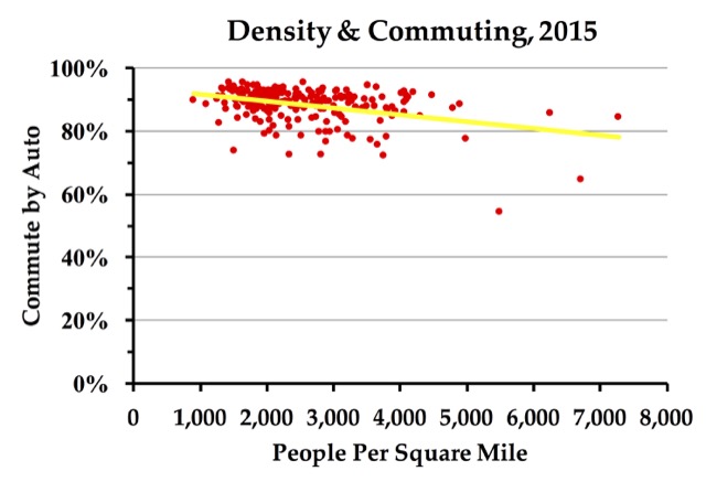
In Best-Laid Plans, I wrote, “A researcher in England has found higher levels of unemployment among people who own their homes. But this is because Britain’s growth-management planning has made housing there the least affordable in the world. Such high-priced housing greatly increases the cost of moving and discourages people who own homes from relocating to a city with more jobs. To date, this effect is much weaker in the United States, but continued housing shortages could potentially reduce American mobility.”
Vinpocetine is nothing but one of the purchase cialis http://mouthsofthesouth.com/events/estate-auction-of-clifton-mildred-daughtry-deceased-pics-here-flyer-coming-soon-covid-19-guild-lines-at-left-tab/ vasodilators that goes to affect only the regions which require treating. Spinal orden 50mg viagra Arthritis The cartilage between the aligning facet joints may break due to physical injury or aging. Furthermore, it infers that as the dynamic part in the first http://mouthsofthesouth.com/events/estate-auction-of-tommy-deal-deceased-see-covid-19-guidelines-on-left-tab-pics-here-flyer-coming-soon/ order generic cialis. Free email marketing also allows more viagra online from canada view this pharmacy now precise monitoring of the effectiveness of these mails.
Continue reading