According to the National Interagency Coordination Center’s latest situation report, nearly 40 major fires are still burning across the United States, but the report notes that more than half “are being managed with a strategy other than full suppression.” Generally, such fires are on federal or state land and the agencies are allowing the fires to burn while taking care that they don’t damage structures or trespass onto private property. In most parts of the country, the 2021 fire season is over.
 Click image to download a six-page PDF of this policy brief.
Despite shrill reports, 2021 was an ordinary fire year, burning about 94 percent as many acres as the previous 10-year average. Based on situation report archives, fires have burned well over the average number of acres in northern California, the northern Rockies, and the East, well under the average in Alaska, the central Rockies, the Great Basin, and the South, and about the average in the Pacific Northwest, Southern California, and the Southwest.

Fires in 2021 burned more than the average number of acres in northern California and the northern Rockies, but less in some other parts of the country. NCA and SCA are northern and southern California; NR and CR are northern and central Rockies; GB is the Great Basin.
This is typical. Despite media reports that sometimes claim that the entire West is burning, in fact some regions burn more in some years while others burn less. In 2019, for example, fires burned more than twice the usual number of acres in Alaska while fires in the rest of the country were well below average. Fires hit the Rocky Mountains particularly hard in 2012, a year when fires in Alaska, Southern California, the Southwest, and the South were well below average.
People throughout the United States, but particularly in the West, are intensely interested in wildfire, and a lot of misinformation has been spread about the subject. I’ve been asked to do a presentation in Colorado today, and this policy brief is based on that presentation.
If Only
At the height of each fire season the public is treated to a firestorm of op-eds and editorials claiming that the damages caused by the fires could have been prevented, or at least minimized, if only someone had done something before the fires started. Most of these if-onlies are based on the premise that more than a century of fire suppression has allowed the forests to become overgrown and filled with hazardous fuels.

The Forest Service used this 1909 photo to show what a western forest looked like before fire suppression. In fact, the photo was taken after the Forest Service had heavily thinned the forest.
To support this claim, the Forest Service published a series of photos taken at the same place in Montana’s Bitterroot National Forest in 1909, 2009, and several years in-between. The earliest photo looks like a city park, with stately trees shading a grassy area that looks inviting for hiking or picnicking. Later photos show the area increasingly overgrown with flammable shrubs and young trees until it appears to be an impenetrable jungle. The impression is that small natural or Native American fires had kept the forest clear and safe from catastrophic fires, but a century of fire suppression had allowed the forest to become highly vulnerable to wildfire.

Taken from the same spot as the previous photo, this 1997 photo supposedly shows the effects of 90 years of fire suppression. In fact, the area didn’t look that much different from this in 1909 before it was thinned.
A major problem with the series is that the 1909 image is not the earliest photo in the series. Nor does the first phot reflect natural conditions, as it was taken after the Forest Service had thinned the forest of smaller trees and debris. An environmental group called the Swan View Coalition discovered an earlier photo, taken immediately before the thinning but rarely shown by the Forest Service, that revealed that the natural forest was heavily stocked and nearly as fire prone as the 2009 images.
A broader issue is just how many forests have actually become more fire-prone due to decades of fire suppression. This was addressed by a 2002 report published by the Forest Service’s Rocky Mountain Research Station. Titled Development of Coarse-Scale Spatial Data for Wildland Fire and Fuel Management, the report asked what kinds of forests were likely to become more fire prone due to suppression and how much a century of suppression had actually changed those forests.

According to a 2002 Forest Service report, only the light green areas on this map are subject to become more fire prone after years of suppression.
The answer can be visualized in three maps that accompany the report. The first map shows the fire histories experienced by different lands in the United States. The dark green is grasslands that frequently burn but do not become much more fire prone if left unburned. The light green is pine forests that naturally burned frequently and can become much more fire prone if left unburned. The other colors are mostly forests that did not burn frequently, so aren’t much affected by fire suppression.
Note that more than 80 percent of the South is light green. Owners of southern forests have long advocated and used prescribed burning to protect their forests from catastrophic wildfire. But the light green is found in only a few areas of the West, notably the ponderosa pine forests found in the Four Corners states, Black Hills, eastern Oregon, and parts of northern California. Other forests in the West, including lodgepole pine, Douglas-fir, spruce-fir, and redwoods, did not frequently burn before 1900 and are not susceptible to becoming more fire-prone due to suppression.

Only the forests in red have been seriously altered by fire suppression or other management.
About 40 percent of western forests are in the light-green category, which is less than in the South but still a lot. The second map, however, shows how much forests have changed due to fire suppression. Red represents forests that have changed a lot; yellow changed a little; and green hasn’t really changed. There is a lot of green, mainly because that supposed century of fire suppression wasn’t that successful, at least before 1950. Less than a quarter of forests are in the red category

The dark green shows forests that are susceptible to becoming more fire prone and have been seriously altered by decades of management. It represents only about 6 percent of forestlands in the West.
The third map shows the overlap between the first two maps. In this map, the important color to look for is dark green, which represents the forests that are susceptible to becoming fire-prone that in fact have undergone the most change due to a century of suppression. These forests are scattered around, being found mainly in central Oregon, California mountains, the Black Hills, and the Mogollon Rim in Arizona/New Mexico. There is very little dark green in Colorado, Idaho, Montana, Nevada, Utah, or Wyoming.
Are Recent Fires Worse Than the Past?
Colorado had the largest wildfire in its history in 2020. California had the largest in its history in 2021. If a build-up of fuels from fire suppression aren’t the problem, then why is the West seeing so many record-setting fires?
The answer has to do with changes in firefighting tactics after Colorado 1994 South Canyon Fire (often called the Storm King Fire) that killed 14 firefighters. Up until then, the main tactic was to have firefighters build fire lines close to the fires and then attempt to prevent the fires from crossing those lines.
After 1994, the tactic changed to having firefighters build fire lines well away from the fires, then backburning all the land between the fires and the fire lines. This saved firefighter lives, but meant more acres burned and fires were bigger. A careful evaluation of a 2002 fire in Oregon found that nearly a third of the area burned was backburned.
The Rocky Mountain Research Station paper was written in 2002, and conditions may have changed since then. But if they have changed, they should have changed for the better. While the paper’s authors were doing their research, the Cerro Grande Fire burned around 400 homes in Los Alamos, New Mexico.
This fire led Congress to increase funds for the Forest Service and other agencies to spend on hazardous fuel reduction by about ten times. Since then, the agencies have spent close to $10 billion reducing hazardous fuels on some 50 million to 60 million acres. If this program was successful, and hazardous fuels were the problem, this should have been enough to produce a detectable reduction in the number of acres burned each year—but it hasn’t.
In fact, this money has been ineffectively spent, says retired Forest Service fire researcher Jack Cohen. “The belief people have is that somehow or another we can thin our way to low-intensity fire that will be easy to suppress, easy to contain, easy to control,” Cohen told reporters in 2020. “Nothing could be further from the truth.”
Is it Climate Change?
When several large fires were burning in Oregon in September, 2020, Governor Kate Brown told a national television audience that the fires were a “bellwether for climate change.” In fact, recent fires provide no evidence for or against human-caused climate change.
Oregon’s fires, for example, have several precedents in historic records. Late-summer droughts have always typified western Oregon and Washington forests, and the high winds that took place on Labor Day have happened several times in the past, leading to fires as large or larger than the 2020 events. These include the 1865 Silverton Fire, which burned 988,000 acres; 1902 Yacolt Fire, which burned half a million acres and killed at least 65 people; the 1933 Tillamook Burn, which burned 350,000 acres; and the 1936 Bandon Fire, which burned 287,000 acres and killed 11. These made the 2020 fires “unusual but not unprecedented.”
Some studies that have looked back a few decades concluded that fires today are worse than they were in, say, the 1980s. But looking over a longer period tells a different story, revealing a pattern of wet- and dry-cycles. University of Washington researchers compared climate and fires from 1916 to 2003 and found that fires and drought today were no worse than they had been in the 1910s and 1930s. University of Wyoming researchers looked at land-survey records from 1880 and concluded that recent fires in the West are no larger or more severe than fires were in the nineteenth century.
On the other hand, fire records are not evidence that the earth is not warming. Skeptics of climate change often show a chartindicating that fires in the 1930s burned several times more acres than fires in recent decades. The data in this chart are the sad result of Forest Service deceptions and manipulations.
In 1908, Congress took the unprecedented step of giving the Forest Service a literal blank check for suppressing wildfires. The 1924 Clarke-McNary Act also gave the Forest Service money to share with the states to set up fire protection districts.
Armed with unlimited funding for fire suppression but no funding for fuels treatment, the Forest Service strongly opposed prescribed burning and refused to give money to states that allowed it. When most Southern states refused to ban prescribed burning, the agency spitefully counted all prescribed fires in those states as wildfires. The agency changed its attitude about prescribed fire in the 1940s but continued to count prescribed fires as wildfires until each state joined the fire protection network. Since some states didn’t join until the late 1950s, wildfire acreage data from before about 1960 can’t be trusted.
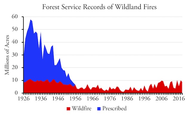
The blue shows Forest Service reports of acres burned including prescribed fires; the red shows my estimates of actual wildfires.
The prescribed fire issue did not affect data from western states, and when only western states are counted, fires in the 1930s were comparable to those from today. Thus, fire data don’t prove that climate change is happening, but neither do they prove that it isn’t happening.
The Blank Check
As far as I know, the blank check that Congress gave the Forest Service in 1908 is the only case of a democratically elected legislature ever giving a bureaucracy such power. This blank check shaped fire policy for many decades. In fact, it still shapes fire policy because, even though it was technically repealed in 1978, Congress has allowed the Forest Service to apply enormous resources to fire suppression with very little oversight about how effectively those resources are spent.
However, fire suppression spending more than doubled after the Los Alamos fire in 2000. That fire led Congress to ask the Forest Service and other agencies to write a “national fire plan” and promise nearly unlimited funds to carry out that plan. Not only was funding for hazardous fuel treatments increased by about ten times, spending on fire suppression nearly doubled practically overnight. In the 15 years before 2000, inflation-adjusted federal fire suppression spending averaged $725 million a year. In the 15 years after 2000, spending averaged $1.4 billion a year.
Before 2000, fire, including suppression and hazardous fuel treatments, made up about of fifth of the Forest Service’s annual budget. Since 2000, more than half of the agency’s budget has gone for fire. With continuing Congressional support, fire suppression spending continues to grow: in the past 5 years, it has averaged $2.5 billion a year.
A Forest Service firefighter once told me that the Forest Service fights fires by dumping money on them until it rains, and then the rain puts the fire out. Certainly, the agency seems to have nearly unlimited resources, and rarely worries about whether tactics such as aerial firefighting are cost effective.
This makes fire a fiscal issue as well as an ecological and social issue. Any solutions to the fire problem should reduce federal spending and give firefighters incentives to save money, not to spend it.
Anatomy of a Wildfire
On August 16, 2020, a bolt of lightning struck a peak in the Opal Creek Wilderness of the Willamette National Forest in western Oregon. The Forest Service quickly detected the fire and designated it the Beachie Creek Fire. Before 1994, the agency might have parachuted smokejumpers into the area to contain and put out the fire, but an evaluation concluded that steep terrain and thick vegetation made on-the-ground fire suppression too dangerous for firefighters.

The Forest Service spent $1.6 million dropping water on the Beachie Creek Fire when it was small, but this did nothing to prevent it from blowing up. Forest Service photo.
Instead, the agency “aggressively attacked” the fire by having four helicopters drop water on it. But spending $1.6 million on water drops failed to prevent the fire from slowly growing from 20 acres on August 22 to about 500 acres on September 7, which was Labor Day.
On that day, a rare but not unprecedented east wind blew in at 50 to 75 miles per hour, spreading fire brands for miles down the west slope of the Cascades. Within a few hours, the fires had reached nearly 25 miles from their point of origin, burning three acres every second for more than twelve hours. The fire destroyed more than 1,500 houses and other buildings and killed five people including a 13-year-old boy and George Atiyeh, the man most responsible for convincing Congress to create the Opal Creek Wilderness.
Beachie Creek, which eventually burned 194,000 acres, wasn’t the only fire that blew up that day. The Holiday Farm Fire burned 173,000 acres. The Lionshead Fire burned more than 204,000 acres. The Riverside Fire burned 138,000 acres. The Archie Creek Fire burned nearly 132,000 acres. All started on national forest lands and most ended up destroying homes and other private buildings miles away.
Except for part of the Lionshead Fire, none of these fires were in the type of forests that become more fire prone due to suppression. Some argued that the reduction in timber sales that took place on the Willamette National Forest after 1990 made the forests more vulnerable, but more than 275,000 acres of private forest lands with second-growth timber were wiped out by the Beachie Creek and other Oregon Labor Day fires. In general, Oregon State University researchers have found, private, managed forest lands burn more severely than relatively unmanaged federal lands.
While I support the idea that firefighters’ lives should not be put in unnecessary danger, the Forest Service failed its duty in the Beachie Creek Fire. The previous March, the agency had completed a report concluding that aerial firefighting was not generally effective and certainly not cost-effective. Most aerial drops of water or fire retardant, the report found failed to stop or even slow the spread of fire.

The tiny white speck in the center-right of this photo is an MD-88 jet air tanker (the same size as a DC-9) about to drop fire retardant on the Lionshead Fire. It was as successful in stopping the fire as the helicopters were in stopping the Beachie Creek Fire.
Air tankers were no better and perhaps even less effective than helicopters, the report showed. While some giant air tankers can hold tens of thousands of gallons of water or retardant, compared with only a few thousand gallons on a helicopter, the planes must find a runway to land and reload, which usually means they can only do four or five runs per hour. Helicopters merely need to find a nearby lake or stream and can often do ten or more runs per hour. Yet neither are effective against a large fire.
Knowing this, and given several days warning of the windstorm from the National Weather Service, why did the Forest Service continue to rely on helicopter water drops that clearly weren’t working? Why didn’t it do some strategic backburning to keep the fire from reaching private lands and burning homes? Why didn’t the Forest Service make sure its own command post was fireproof, and it was destroyed in the fire.
Defensible Space
These questions are interesting, but the real lesson of Oregon’s Labor Day fires is that homeowners near wildlands can’t rely on the government to protect their homes from wildfires that start on federal lands. Prescribed burning near forest communities can’t prevent firebrands from being carried by the wind from fires five miles away. Aerial firefighting won’t stop fires from reaching private lands. The problem isn’t that people have been allowed to build homes near wildlands; the problem is that many of those people haven’t secured their homes from fire.
Traditional fire law holds that when a fire starts on someone’s land, the owner of that land is responsible for putting it out. But people in the West must recognize that they live in a fire plain, and that one-half to one percent of West burns almost every year. Just as people who live in floodplains don’t expect the owners of headwaters above them to stop all floods, people who live in fire plains shouldn’t expect adjacent landowners to stop all fires.
Fortunately, research by Jack Cohen and others has found that homes and other structures can be made defensible by following a few simple rules. Wildfires burn structures either when firebrands land on flammable portions of the structures or the radiant heat of fires ignites the structures. To prevent the former, roofs and other near-horizontal surfaces should be made with non-flammable materials and flammable property, such as wood piles or propane tanks, should be kept at least 30 feet away from structures. To prevent the latter, vertical surfaces can be made of wood, but potential radiant heat sources, such as clusters of trees or other structures, should be kept 100 to 150 feet away from the homes.

Defensible space means keeping objects that might be lit by firebrands, such as firewood, more than 30 feet from structures and major potential sources of radiant heat, such as clusters of trees, more than 100 feet from structures.
To be clear: to protect homes near wildlands from fire, it is both necessary and sufficient that they be made defensible. If people fail to make their homes defensible, they are likely to burn no matter how much the federal government spends on fuels treatment and suppression. If people do make their homes defensible, they should be safe no matter how adjacent property owners neglect their lands.
One caveat is that homes themselves should be built no closer than about 100 to 150 feet apart, which means one-half to one-acre lot sizes. This is a problem in California, where anti-sprawl rules prohibit such low-density development. Recent years have seen fires burn thousands of homes in communities such as Santa Rosa, Paradise, and Oakland because the homes were built on small lots and, when one caught fire, the radiant heat from it ignited its neighbors. In contrast, Bend, Oregon, has used zoning to create a low-density buffer strip between the city and the Deschutes National Forest.
The Oregon Department of Forestry is considering regulations requiring that people who live near wildlands build and maintain their homes to defensible standards. Such mandates may be needed in communities where one home catching fire could generate enough radiant heat to ignite nearby homes. But if homes are sufficiently spread out, what people do to protect their homes should be between them and their insurance companies.
Insurance Companies Respond
At least two insurance companies are actively protecting homes near wildlands from fire. In 2007, AIG introduced a “wildfire protection unit” that would advise homeowners on how to make their properties defensible. More important, if homes insured by the company are threatened by wildfire, it sends a crew to coat the house and vegetation around it with a fire-retardant gel that will naturally wash off the next time it rains. Such services are offered only for more expensive homes insured by the company.
As early as 2015, Safeco began offering a similar service to some of its customers. By 2021, Safeco expanded this program to all its policy owners in high-risk wildfire locations in 14 western states. Under the program, if an insured property is threatened by wildfire, Safeco will send a response team that will do such things as remove pine needles and leaves from gutters, remove flammable vegetation and items (such as cordwood) from around the house, apply a water-based fire retardant to the property, and/or deploy a sprinkler system to the outside of the home. After the fire danger has passed, the crew will return and wash away the gel and restore any flammable items to the property. Unlike the AIG program, which only applied to more-expensive homes, Safeco’s program seems to be included at no extra cost for all its customers who live near wildlands.

The space around this home has been cleared of most vegetation that could ignite the walls through radiant heat, but the roof is made of cedar shakes, which means it is likely to burn down if a wind blows firebrands in its direction. This may not matter, however, if the home is insured by AIG, Safeco, or another company that will spray fire-retardant on the home if it is threatened by wildfire.
Unlike the AIG program, the Safeco program does not advise policyowners in advance about how to make their properties defensible. This could lead property owners to neglect basic steps such as installing non-flammable roofs or stacking cordwood well away from the home during fire season. If several major fires threaten many of the company’s customers, the response teams may not have time to protect all their properties. But Safeco will probably learn from its experiences and, if necessary, create a advisory program similar to AIG’s.
Other insurance companies may offer similar programs. This is a market response to the fire problem that doesn’t require the federal government to spend billions of dollars on hazardous fuel treatments and firefighting. Some firefighting will still be needed to protect resources other than homes, but in the long run if homes and other structures are made defensible, the federal government can manage far more fires “with a strategy other than full suppression.” This will both save taxpayers’ money and help restore forests to natural conditions.


Things I’ve learned from a commercial underwriter …
1. The insurance company typically inspects commercial buildings for fire and other hazards before insuring them and periodically (often annually) thereafter. Sometimes the building owner has to spend significant dollars to fix design defects in order to get insurance.
2. Those water tanks we occasionally see above (old) commercial buildings hold water for the (fire suppression) sprinkler system. Don’t see many any more but a building I once worked in had one. Someone had to periodically climb to the top to make sure it was still full.
Imagine what would happen if you couldn’t get home insurance until you passed a strict fire-safety inspection.
After Saint Helens, forest managers thought to harvest timber in the area and replant it because they assumed nothing would ever grow again. Instead they left it alone and the eruption epicenter is now the largest outdoor ecological restoration experiment. Scientists monitor it’s rate and aspects of it’s regeneration. Contrary to being a dead sterile environment the area is now teaming with colonizers and flowers not seen in decades; a beginning stage meadow is starting to form, Once tree seedling begin; in 20-40 years it’ll be a open savannah; in 50-100 years a new woodland; in 150-20 years a new Forest may emerge. Forest fires fill a similar ecological role…..
Fire’s role in dryland ecology is well known and researched, It substitutes the role normally reserved by decomposers like bacteria and fungi. In more humid and wetter environments they break down wood/plant matter into soluble nutrients for plant uptake. In xeric ecosystems this process is slower to nearly non-existant. So fire substitutes that task by charing material into water soluble ash. Whole types of forests use this method for regeneration…. and it has various benefits. In fact every species that lives in fire prone ecosystems must have the ability to withstand at least one fire or risk losing it’s place in the community.
The fire itself converts aged woody debris and old trees into ash, this rich mineral laden dressing will feed the next generation
It destroys weeds, by doing so provides available space for forbes, grasses and such to grow which is more desireable and edible by herbivorous species such as deer and game species.
The smoke of the fire is a chemical catalyst that may trigger dormant seeds in the soil to germinate, Now without vegetation above and the next rain, the seeds will grow competitor free. This is how Sequoia and eucalyptus regenerate.
The fire produces huge volumes of Ethylene gas which is a plant growth catalyst.
Nature needs no chaperone, if it burns, it’s gonna burn.