
In 1989, when Vickie and I decided to move from Eugene to Portland so I could work on the SP&S 700, home prices in Portland were starting to rise following the recession of the 1980s. We soon realized that we couldn’t afford a home in Portland, but we did find a nice house in a Portland suburb called Oak Grove. Having grown up in Portland, I was aware that Oak Grove was located a few miles south of the city on the east side of the Willamette River, but I didn’t know much about it.
I soon learned that Oak Grove is an unincorporated area that had exclusively been farmland until 1892, when the world’s first electric interurban railroad connected the 20-mile distance between Portland and Oregon City, Oregon’s oldest incorporated city. Wealthy Portlanders soon realized that they could “get away from it all” by building homes along the rail line and commuting.
By 1930, parts of Oak Grove nearest the trolley line had been subdivided into standard 50×100 lots centered around a small retail area. But much of the community was a “railroad suburb,” with large houses on parcels of an acre or more, interspersed with farms and dairies. Over succeeding generations, the large parcels and farms were broken up and sold off. Today, the community has a wide variety of lot sizes and home styles.
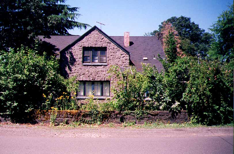
The block I lived on, for example, was part of a former dairy farm and covers twenty-two acres. This itself is unusual–most city blocks are a tenth that size–but it is by no means the largest in Oak Grove. Individual lots on our block ranged from 7,000 square feet to 50,000 square feet or more (an acre is 43,560 square feet, slightly smaller than a regulation football field). At least one vacant lot was well over an acre in size. The house we bought was on a lot 50 feet wide and 300 feet deep, just over a third of an acre. We used our long backyard for gardening and playing frisbee and other games with our dog, Chip.
The oldest homes on the block were built around the turn of the century; the newest just a few years before we moved in. Since the houses were built one-by-one over a one-hundred-year period, each was unique, with some made of native rock by a pioneer family of Italian stonemasons–rare in the timber-rich Northwest.
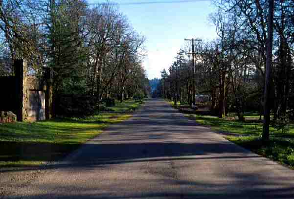
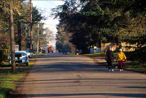
The community had less than 70 percent of the population density of other Portland-area residential areas. Such a low density means there was little auto traffic. Chip and I typically walked four miles a day down the centers of the sidewalk-free streets, meeting others who were also out walking or bicycling and rarely having to make way for cars. Many people took advantage of their large yards to grow flowers and vegetables, and a few own livestock such as poultry, goats, sheep, horses, and even a donkey.
Oak Grove’s glory days as a wealthy community are long past: Today, except for those whose homes front on the river, most residents are blue-collar workers. The decline in wealth is probably due to the community’s age and the many subdivisions of formerly large estates, neither of which are attractive to yuppies. This was fortunate for me, for otherwise I couldn’t have afforded to live in such a low-density area.
Neighbors told me Oak Grove reached a low point around 1980, when it was known as “the bad part of town,” with crack houses and other forms of crime. There was no evidence of that when I lived there, and the neighborhood has been improving ever since.
Though an unincorporated area, most of the community needs were met by three special service districts: one for fire, one for water, and one for sewers. Land-use planning, however, was handled by the Clackamas County planning bureau.
In 1995, while Forest Service timber sales were rapidly declining and I was trying to start a career studying other agencies, a neighbor who I had never met put a handwritten note in my mailbox asking me to come to a planning meeting. I might have ignored it but there was a slight sense of desperation in the note. It turned out to have been written by Jeanne Johnson, who lived in one of the nicer homes on my block.
At the meeting, I learned that county planners had been working for six months with local residents on a “transportation and growth management plan.” The purpose of the plan, planners claimed, was to give people more opportunities to walk and ride their bicycles. This seemed peculiar since no one I knew had ever felt hesitant to walk or bicycle around the neighborhood.
Then they showed us a map of the plan. The block I lived on and several nearby were to be rezoned for 5,000-square-foot minimum lot sizes. Homeowners in this zone would also be allowed to build “granny flats,” or small apartments, into their homes–effectively turning many into duplexes. The block across the street plus many others would be rezoned for multi-family dwellings with 24 units per acre (about 1,800 square feet of land per unit). Except for a senior center, no other apartments in the vicinity had more than twelve units per acre.
To give people a place to walk to, a significant chunk of our neighborhood would be “mixed use,” with stores and other businesses located a few steps from residences. Planners wanted the multi-family dwellings in this area, which they called the “town center,” to be three stories high–two stories is the current limit–with businesses occupying the street floor.
The goal was to quadruple population densities in the “downtown” area and double them elsewhere. We were assured that this “densification,” as the planners called it, was for our own good and that it would encourage walking and discourage cars. We were also told that we had little choice in the matter, because a new plan that Metro was preparing, called the “2040 plan,” would force planners to densify Oak Grove whether we liked it or not.
Neotraditionalism and Oak Grove
When my neighbors and I began criticizing the county plan for Oak Grove, we were immediately asked why we hadn’t been to earlier planning meetings, which had been going on for several months. It turned out that a notice of the first meeting had been sent to most Oak Grove residents in a newsletter put out by the local sewer, water, and fire districts.
But the meeting notice said nothing about densification, mixed uses, or multi-family zoning. Instead, it concentrated on “making the Oak Grove community more pedestrian-oriented, with walking trails and bicycle paths.” It also mentioned “revitalizing the downtown area”–but not design codes, granny flats, or any of the other controversial ideas.
At the beginning of the planning process, the county also conducted a “scientific survey” of local residents. As it happens, I was one of the people surveyed. Again, the survey concentrated exclusively on transportation, asking if I would like more bike trails or lanes, and so forth. There was nothing in the survey to hint that the county was planning to rezone the neighborhood for higher densities.
The term “New Urbanism” hadn’t yet become popular; county planners instead called their ideas “Neotraditionalism.” They seemed to firmly believe that densification would lead people to drive less and walk more; more specifically, that people would drive less if they lived in neighborhoods that were like the ones designed before cars were universal. This included high residential densities, mixtures of residential and commercial uses, narrower streets, and such design features as broad front porches and bay windows. The fact that people who still lived in such neighborhoods drove a lot was ignored.
When one of my neighbors asked about the reasoning behind these ideas, planners responded with totally circuitous logic. Why did planners want to densify our community? “Because densification is part of the Neotraditional concept.” What is Neotraditionalism? “Neotraditionalism is a planning concept that calls for densification.”
As noted in chapter 12, I had heard something like these ideas before when I entered planning school in 1977. Alone among planning students, I also took a class in urban economics, where we built a model of an urban economy, tested the model against reality, and improved the model until we could ask such questions as “What happens to congestion if we densify a city within an urban-growth boundary?” The model clearly showed that congestion increased.
Meanwhile, everyone in my urban planning classes, including three professors, believed that density would reduce congestion. No one considered looking at data, building a model, or otherwise testing this assumption. That was when I decided not to be an urban planner; now, these ideas were coming back to haunt me.
Clackamas County planners had already zoned a parcel of farmland to become a high-density, Neotraditional development. But planners everywhere knew it was not enough to build new Neotraditional suburbs. To dramatically reduce auto use, they would also have to redesign existing suburbs along Neotraditional lines. No one knew if that was possible.
To find out, the Oregon Department of Transportation offered federal grant monies to local jurisdictions that would volunteer to impose Neotraditional designs on existing neighborhoods. Clackamas County decided to volunteer Oak Grove and received a $34,000 grant from the state.
How did the county happen to pick Oak Grove? Because, planners said, Metro had designated Oak Grove a “town center” in its draft 2040 plan. A town center, says Metro, has “compact development and transit service” with “local shopping and employment.” Its population density of 31 people per acre would be about four times Oak Grove’s current average density.
At the time, I knew little about Metro except that it had something to do with garbage collection and recycling. “Metro is predicting that 500,000 people are going to move to Portland in the next twenty years, and we have to find room for them,” we were told. “Metro is writing a plan to densify the entire city, and we have to do our part.”
In addition to “land use and redevelopment,” the group had two other committees: “transportation” and “downtown revitalization.”
Making Oak Grove Safe for 50×100 Lots
The transportation committee was supposed to make the neighborhood safer for cyclists and pedestrians. But planners also wanted to build more streets to give people better “access.” What they didn’t say was that they really wanted to make it easier for people to subdivide large lots into 50-by-100-foot parcels–which is hard when the blocks are 600-feet by 1,500-feet.
Nearly everyone in the neighborhood agreed that they didn’t want new streets. So planners suggested that bikeways and pedestrian paths be built across some of the larger blocks. That sounded all right to most people, and they drew lines on maps to show where pedestrian ways might go.
This led to an interesting exchange between two of the planners at the next meeting:
Planner 1: We are proposing to construct a number of pedestrian ways. We have located these on maps, and have examined aerial photos to make sure they can be built. We don’t think any will have to go through anyone’s houses.
Planner 2 (firmly): None will have to go through people’s houses.
Planner 1: (as if he misheard) Some may have to go through people’s houses.
Planner 2: (more forcefully) None will have to go through people’s houses.
Planner 1: (puzzled) Some will have to go through people’s houses?
Planner 2: Oh, all right, it looks like they will have to go through just three houses.
Then someone asked, “Are these pedestrian ways going to be barricaded so people can’t drive their cars down them?”
“Oh, no,” said planner 2. “We can’t deny anyone access to their property.” Why would people need access to their backyards?–unless the “pedestrian ways” were really just another way of encouraging people to subdivide their large lots. Sensing this, the committee unanimously vetoed that idea.
The transportation committee ended up making recommendations for bike lanes but against new sidewalks on most streets as well as most of the other ideas planners had.
Preserving the Historic Character of Downtown
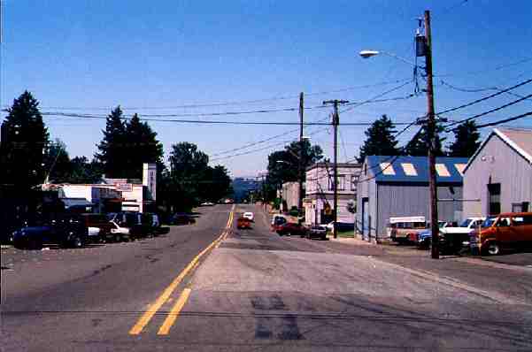
Oak Grove’s downtown included a number of shops and a machine works located at the intersection of the former streetcar line and Oak Grove Boulevard, the area’s “main street.” In 1933, the state built a four-lane paralleling the interurban line but about a half-mile east of downtown Oak Grove. Locals still called the new road the “superhighway.” The downtown area declined as most businesses moved out to or were replaced by ones on the highway.
Beyond the two-block long downtown, Oak Grove Boulevard stretches through a neighborhood of large, historic homes until it reaches the highway. Until recently, the downtown area had a full-sized supermarket, but poor management (some say) plus competition from larger and lower-priced markets on the highway put it out of business. Remaining shops include, among others, two convenience stores, a karate studio, a tavern, and a beauty parlor. A few of the shops were in former houses that had ugly false fronts to make it look like they were made to be stores.
A Neotraditional redevelopment of Oak Grove would replace most of the buildings downtown with three- or four-story mixed-use apartments that had shops and businesses on the ground level. But planners didn’t dwell on this, emphasizing instead sidewalk configurations, planting trees, and other features of street design–most of which, they reluctantly admitted, would have to be paid for by local property owners.
Curiously, planners’ maps defined “downtown” as not just the four blocks of businesses but also the half-mile-long stretch between the businesses and the highway. The many large homes on this street included what to my mind was one of the most beautiful solid stone houses in east Portland.
So I was stunned when the planner from the revitalization committee announced that, “To preserve the historic character of downtown Oak Grove, we propose to allow zero-foot setbacks of buildings.” How does allowing people to tear down or build false fronts on existing structures “preserve” their historic character?
I wondered if I had misheard this statement. But at a later meeting planners distributed the proposed zoning codes for “town centers” and “town center residential.” The town center code allowed no setbacks. The town center residential code changed traditional minimum setbacks of thirty feet from the street into maximum setbacks of eighteen feet, while setbacks between properties were changed from a traditional minimum of five feet to zero.
In other words, the codes encouraged owners of the historic homes on Oak Grove Boulevard to tear down their homes and build row houses or apartments. Someone who owned a home on a one-acre lot would not be allowed to subdivide and build one or two new homes. If they subdivided at all, they would be required to build apartments, row houses, or other suitably dense developments. No one would be forced to subdivide, but after a few did, many others–preferring to live in a less dense neighborhood–would probably sell out too.
The codes also included numerous design frills. Roofs must be hipped or gambrelled, not flat; shops had to have at least 19 feet of window space for every 25 feet of street frontage; “consistent design elements shall be used throughout the district to ensure that the entire area is visually and functionally unified.” Individualism and history would be replaced by unity and cute design.
We didn’t know it, but the Oak Grove plan was part of a larger plan written by Metro, Portland’s regional planning agency, which in turn was responding to state land-use planning laws and regulations. Fighting the plan meant dealing with the county planners, the county commission, Metro, and ultimately the state’s Land Conservation and Development Commission. If we had known how hard it was going to be, we might have given up at the start. Fortunately, we didn’t.


Somehow, I truly doubt any of the planners at the Oak Grove meetings were confused. It’s all a big act while they lie through their teeth. Government planners are mostly just professional liars whose job it is to come up with post ad hoc excuses for decisions that have already been made.
”
Chip and I typically walked four miles a day down the centers of the sidewalk-free streets, meeting others who were also out walking or bicycling and rarely having to make way for cars.
”
It’s great to see people making this observation. I often have to remind my urbanista friends that I’ll take the out of the way suburban streets where my sister lived than the sidewalks of Minneapolis, especially in the winter. I found when at her place it was easy to walk. The streets were well plowed and with little traffic and wide, they functioned as a great clear ice-free walk.
Contrast that with Minneapolis where half the sidewalks were either not cleared or cleared so well they were packed with ice.
For those not familiar with ice, you don’t want to slip and fall. People have ruined their backs for the rest of their lives. Or ended up going to the hospital because of the fall.
Minneapolis does one better with their downtown skyway system. In fact, I’m surprised antiplanner hasn’t done a piece about it. It was created in the 60s by a group of downtown businessmen who were trying to stop the loss of customers to suburban shopping malls by creating the indoor experience in the city. Today, these enclosed bridges connect 80 city blocks and are extremely popular during the winter. And of course, a lot of busybodies don’t like this system, they complain that it leaves the sidewalks empty. Because to them, people choosing a superior mode of getting around is a bad thing and they should freeze to death and dodge traffic and wait at crosswalks because otherwise it’s not a real city.