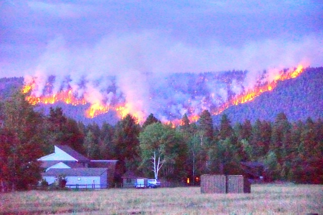
Where There’s Smoke, There’s Fire

The Antiplanner’s exurban area has been filled with smoke the last few days as winds have blown soot from wildfires in western Oregon towards central Oregon. As bad as the air has been here, it usually wasn’t as bad as it was in New York City a couple of months ago due to fires in Canada.

Smoke obscures the sun from New York’s Long Island in June 2023. Photo by Don Sutherland.

Canada has seen more land burn so far this year — more than 34 million acres as of August 18 — than any full year in its history: the previous record was 17.5 million acres for all of 1995. The Maui fires, of course, have had unprecedented impacts, with at least 115 known dead to date and more than 1,000 missing. Many are blaming these fires on or saying they are evidence of human-caused climate change. Continue reading

Pouring Fuel on the Fire

The Forest Service today seems to believe that its main mission is to reduce hazardous fuels. The agency was spending close to half a billion dollars a year on this program, an amount that was doubled by the 2021 infrastructure bill. Yet there is a huge debate among fire ecologists over whether this program makes any sense.

Would any amount of prescribed burning prevented this 2020 fire from burning thousands of acres?

The latest volley in this debate was published earlier this week in a peer-reviewed journal called Fire. Representing those who disagree with the Forest Service’s fire policy, the paper charges that supporters of the policy have deliberately overlooked evidence that it won’t work. Continue reading

Land-Use Planning in a Fire Plain

Fed by high winds, a wildfire about 50 miles from Antiplanner headquarters in Camp Sherman blew up on Sunday, burning 34,000 acres in a few hours. Meanwhile, Oregon’s Land Conservation & Development Commission (LCDC) is seeking comments on a report it has prepared on “wildfire adapted communities.”

Click image to download a copy of this report (2.9-MB).

The report says little about density other than to suggest that structures be clustered “in areas of lowest risk.” Since the only places in Oregon that are naturally at low risk of wildfire are underwater, this suggests that no “clustering” of development makes sense. Continue reading

Spending More, Getting Less

Agriculture Secretary Tom Vilsack and Forest Service Chief Randy Moore have announced a new strategy to fix the nation’s wildfire crisis. Not surprisingly, the most important part of that strategy is to give them a lot more money.

Click image to download a 34.0-MB PDF of this report.

The Forest Service plan, if it could be called that, consists of two simple steps: 1. Give them enough money to do 5 million additional acres of hazardous fuel treatments a year for ten years. 2. By the time that ten years is up, they promise to write another plan for the next ten years. Continue reading

Boulder’s Open Space and the Marshall Fire

At 11 am on December 30, 2021, a small fire was reported near the intersection of state highway 93 and Marshall Road in Boulder County, Colorado. Though driven by high winds, it took a full hour for the fire to creep across three miles of grasslands to the town of Superior, where it proceeded to burn 533 homes to the ground. It also crossed U.S. 36 into the city of Louisville where it burned another 332 homes, as well as 106 homes in unincorporated areas outside the two cities. In addition to killing at least one and possibly three people, the fire also destroyed about 100 other structures, including a hotel, and damaged 150 or so more. In all, it burned more than 6,000 acres in 30 or so hours before snowfall the evening of December 31 put it out.

Click image to download a four-page PDF of this policy brief.

As it happens, I had given a presentation on wildfire to the Independence Institute, Colorado’s free-market think tank, just two months before the fire. The presentation noted that state and local land-use regulations that require compact development make cities more vulnerable to fire. The Tubbs fire in 2017 destroyed nearly 3,000 homes in Santa Rosa, California and nearby communities while the Camp Fire in 2018 destroyed more than 14,000 homes in Paradise, California and nearby communities. Continue reading

The Truth About Western Wildfire

According to the National Interagency Coordination Center’s latest situation report, nearly 40 major fires are still burning across the United States, but the report notes that more than half “are being managed with a strategy other than full suppression.” Generally, such fires are on federal or state land and the agencies are allowing the fires to burn while taking care that they don’t damage structures or trespass onto private property. In most parts of the country, the 2021 fire season is over.

Click image to download a six-page PDF of this policy brief.

Despite shrill reports, 2021 was an ordinary fire year, burning about 94 percent as many acres as the previous 10-year average. Based on situation report archives, fires have burned well over the average number of acres in northern California, the northern Rockies, and the East, well under the average in Alaska, the central Rockies, the Great Basin, and the South, and about the average in the Pacific Northwest, Southern California, and the Southwest. Continue reading

The Usual Misinformation

It’s fire season again, and so we are treated to various horror stories such as gridlock as people tried to evacuate South Lake Tahoe (though they all got out by 4 pm). These stories are followed by the usual misinformation that is spread around about wildfire.

Firefighters attempted to hold the line on the Dixie Fire in this July 29 photo, but since the photo was taken the fire has grown by more than 20 times. Forest Service photo.

“Wildfires in 2021 are breaking records,” says one report. However, in the United States, only 4.9 million acres have burned so far this year, which is 14 percent less than the last ten-year average of 5.6 million acres through this date. Continue reading

Researchers: Logging Won’t Stop Fires

Despite rain in the valleys and snow in the mountains, wildfires are still smoldering in Oregon and people are still trying to blame those fires on the lack of government spending on logging or prescribed burning. Yet increased logging wouldn’t have stopped western wildfires this year, a number of researchers told reporters in an article jointly written by the Oregonian, Oregon Public Broadcasting, and Propublica.

“The belief people have is that somehow or another we can thin our way to low-intensity fire that will be easy to suppress, easy to contain, easy to control,” retired Forest Service researcher Jack Cohen told the reporters. “Nothing could be further from the truth.” Continue reading

It’s Not Climate Change, Stupid

Early this week, Oregon governor Kate Brown went on national television to call the Pacific Coast fires a “bellwether for climate change.” As UC Berkeley professor of sustainable development Maximilian Auffhammer writes, “It’s the climate change, stupid.”

This is one of four responses to the Pacific Coast fires. Brown and Auffhammer are warmers, people who believe the earth’s climate is changing and the fires must be due to that change. In the warmers’ minds, the fires themselves then become evidence that we need to change our lifestyles to cut back on greenhouse gas emissions.

A second group are the burners, people who believe that a century of fire suppression has led to a dangerous build-up of fuels in the forests. Oregon Senator Ron Wyden falls into this category. He wants to give the Forest Service and other agencies more money and more freedom to do prescribed burning. Continue reading

Wildfire Update

Wildfires continue to burn out of control in much of Oregon, California, and Washington, though they aren’t expanding as fast as they did during last Monday’s wind storm. Most of the Northwest is under a blanket of smoke that is hazardous to our health; the good news is the smoke is cooling temperatures by 10 degrees or so, thus reducing the rate of spread of the fires.

About 1.5 percent of Oregon has burned in the last week with an unusual number of fires burning nearly to the borders of cities such as Ashland, Medford, Oregon City, Roseburg, Salem, and Springfield. Click image for a larger view. Map from Firemappers.

Yesterday’s national situation report was the first I have seen this year in which the number of acres burned exceeded the ten-year average through this date. I downloaded the previous ten years of September 13 reports and found that the Pacific Coast states, central Rockies, and Southwest have all seen more acres burn than the ten-year average, but Alaska, the Northern Rockies, Great Basin, East, and South are well below average. Continue reading