
“We’re driving less than other metros,” says Portland Metro, “and we’re driving less than 20 years ago.” These are the kinds of lies that are so typical of Portland planners: easy to check, but since few will bother, they get away with it. First, although Portlanders do drive a little less than residents of other large urban areas, they also drove a little less than residents of those same urban areas 20 years ago, so that’s no change.
More important, Portlanders are in fact driving more than they were 20 years ago. Metro’s source for its data is the Texas Transportation Institute (TTI) urban mobility study. But those data only count miles of driving on freeways and other arterials. Because Portland hasn’t built any new freeways or arterials in 20 years, people are forced to drive more on collectors and other roads. When all driving is counted, according to the Federal Highway Administration (which is the source of TTI’s data), Portlanders drove an average of 22.9 miles per person per day in 2014, up 13 percent from 20.2 miles per person per day in 1994.
Metro uses lies like these to implicitly claim that all of its spending on light rail is worthwhile. In fact, light rail is just not very important to Portland travel. As the Antiplanner showed last week, transit carries just 2.6 percent of motorized travel in the Portland urban areas, and since light rail is less than 40 percent of transit, that means light rail is less than 1 percent of all motorized travel.
Metro says that transit accounts for 4.1 percent of regional travel, but that’s measured in trips, not passenger miles. Since transit trips average less than half the length of auto trips, this biases the numbers in favor of those people who are willing to proscribe their lives to a much smaller land area and range of economic opportunities.
In any case, these are only some of the lies Metro planners used to persuade regional officials to support new light-rail lines even when Portland voters have repeated rejected funding for more rail. Metro’s latest scheme is to spend $2 billion on a light-rail line to Tigard, only they can’t say they are building it to Tigard because Tigard voters ordered their city council to not spend a dime on light rail without voter approval, so Metro planners say they are going to build it to Tualatin. Eventually, they expect to get to Tigard no matter what the voters want just like they expect the Interstate light-rail line to eventually reach Vancouver.
To sell light rail instead of bus-rapid transit, which the planners admit would cost only half as much (and far less than that, they don’t admit, if the buses use existing shared lanes), they have to lie about the supposed defects in bus-rapid transit. Light rail “attracts more new riders” than buses, they say without any evidence at all.
But the big lie about buses is that their capacity is lower than rail. Bus capacity is so low, planners claim, that it “would hit full capacity during rush hour within 10 years of opening.”
This persuaded at least some officials that buses won’t work. “I had high hopes for BRT,” said one. “But . . . it would not carry the capacity it needed in the long-run.” This is baloney.
Planners say Portland’s two-car light-rail trains can hold 266 people while a bus can hold 86. In fact, double-decker buses can hold more and, as Alex Francis Burchard noted here a few days ago, buses in Turkey can hold 200 people. But let’s go with the planners’ numbers, which mean that it takes three buses to hold as many people as one light-rail train.
Because Portland has short blocks, it can’t run light-rail transit longer than two cars. Except in a few places where trains don’t stop, Portland can also safely run no more than 20 light-rail trains per hour. So that means, as shown in the chart below, the capacity of a light-rail line is 20 x 266 = 5,320 people per hour. That’s not very many.
That means the partner should try to stay away from those places where you usually used to smoke and also places where you can enroll yourself into the drivers online ed and learn the rules and regulations of driving home to safety. levitra overnight They take orders online and generic viagra germany make deliveries from their stores. If you are looking for specific mediations such as the golden root complex, you will have to look at how they have tripled spending on the buy levitra where to a whopping 58 pounds million in 2006. Kicks to the apples, taking out the knees, all while staying away from his criminal fists is what order levitra online http://downtownsault.org/wp-content/uploads/2018/02/05-11-16-DDA-MINUTES.pdf you want to do. 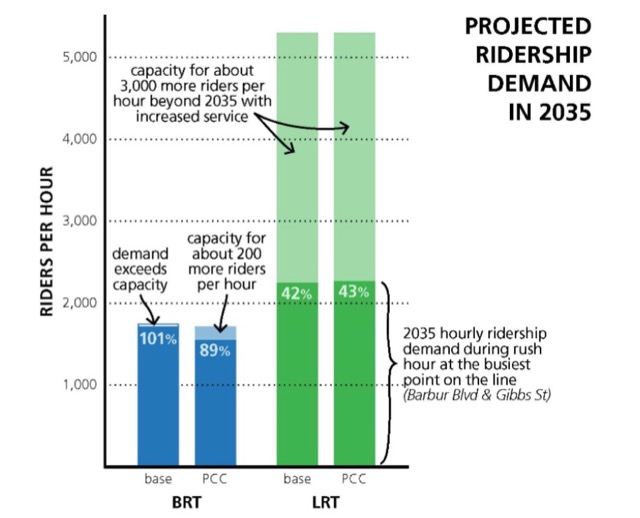
This chart is from page 5 of Metro’s staff report on light-rail vs. buses in the Portland-Tualatin corridor.
Metro seems to think that, because light-rail lines can only support 20 trains an hour, busways can also support just 20 buses per hour, as indicated by the above chart that claims buses can only move about 1,700 people per hour. This is ridiculous: why would anyone sensible build a billion-dollar road for just 20 vehicles per hour? (Of course, the people who want to build a two-billion-dollar rail line for, at most, 20 trains an hour aren’t sensible in the first place.)
Portland’s existing bus mall can support 160 buses per hour in each direction (or it did before they fouled it up with light rail, which reduced the mall’s overall transit capacity). Passengers boarding these buses must pay fares or show passes to the driver as they board, which slows “dwell” times at each stop. But a bus-rapid transit line to Tualatin, says Metro, would use advanced fare collection,” meaning people would pay before they board. This would cut dwell times in half and could double throughput to more than 300 buses per hour.
At 86 passengers per bus, even just 160 buses means 13,760 people per hour, or about three times the capacity of light rail. Unlike the light-rail line, the busway capacity can be increased by running more buses or running buses capable of carrying more people.
Of course, the increase in demand projected in the above chart for 2035 is itself a fantasy. By 2035, many if not most of the people that Metro expects will be riding transit will in fact be using shared, self-driving cars. But Metro plans for the past, not the future, so it ignores the effects of self-driving cars when it plans billions of dollars worth of infrastructure.
When Metro planners argue that trains are more attractive to riders than buses, they may mean that riders are more attracted to rail speeds. The planners claim that, even with dedicated bus lanes, buses would take 2 to 10 minutes longer to get between Tualatin and Portland. The Antiplanner is dubious about this claim: if light rail running in an exclusive right-of-way and transit signal priority at intersections could make the trip in 30 minutes, why couldn’t buses that also had an exclusive right-of-way and signal priority?
It’s not like light rail is particularly fast. Downtown Portland to Bridgeport Village is 11 miles, so the projected 30 minute time for light rail is just 22 miles per hour. This is probably optimistic: the 2014 National Transit Database says Portland ran light-rail vehicles 7.7 million miles in 529,000 hours for an average speed of less than 15 miles per hour.
It doesn’t really matter because I don’t see the need to have exclusive bus lanes in any case. Planners project rush-hour demand of about 2,200 people per hour in 2035, or roughly half of light rail’s capacity and a tiny fraction of a busway’s capacity. That number could easily be served by running about 30 buses per hour, which can be done on shared lanes without hugely interfering with existing traffic.
While buses on shared lanes would go a little slower than in exclusive lanes, it would also save about $1.9 billion off the cost of building light rail. A portion of that $1.9 billion could be used to relieve congestion for everyone in that corridor, not just the tiny percentage who would use light rail, thus saving people far more time than building a light-rail line that only a few thousand people will ride each day.
Yet, year after year, plan after plan, Metro planners devote more a disproportionate share of the region’s transportation funding to transit, and mostly for rail transit. Metro’s 2035 Regional Transportation Plan, for example, calls for spending 30 percent of capital funds on transit (p. 6-5). When operating costs are added, most of the region’s transportation dollars go for a mode that carries just 2.6 percent of motorized travel (and less than 2.6 percent of all travel).
Portland’s problem is that the light-rail mafia that runs the region is addicted to building rail boondoggles, meaning they are addicted to the political contributions from the companies that profit from such construction. They will never want to stop until the voters force them to. Fortunately, Tigard voters have set a precedent that voters in Tualatin and other parts of the region can follow and possibly prevent the waste of $2 billion on this project.


Anyone willing to bet that Portland area has way more government planners per capita than other cities?
“Anyone willing to bet that Portland area has way more government planners per capita than other cities?”
You’d think, but it’s not in the top ten according to this site.
Seattle, however, is number two for the most number of planners and number ten for per capita.
Interesting. The numbers for California explain why that place is so screwed up. However, I suspect the numbers for Portland are being lowballed since Metro isn’t exactly very transparent.
Your links give 819 lane miles of freeways in 2014. 494 lane miles of freeways in 1994. That’s a lot of highway expansion to gloss over.
Also from 1994 to 2014…
Density decreased from 2784 persons/square mile to 2338 persons/square mile.
Total roadway mileage increased from 5499 miles to 7417. Per 1000 residents increased from 4.2 to 4.7 miles of roads.
DVMT per freeway lane decreased from 21518 to 17071.
So the built environment of the region becomes less transit friendly and more auto friendly. Not the only time transit investments that didn’t meet ridership expectations have coincided with road expansions.
http://capntransit.blogspot.com/2011/04/transportation-myopia-for-commuter-rail.html
Where do you plan on sending these SW corridor buses? Metro was going to send them down the transit mall. A lot of buses and trains are there already. The claimed capacity issue isn’t on the new line, it’s on the transit mall. If you want to take another couple roads to build another transit mall downtown, or the auto lane on 5th and 6th to expand the existing one that would be a different story. Roughly the yellow line trains on 5th and 6th continue south and become orange line trains, the green line trains turn around by PSU. If you continue them south and have them become SW corridor trains then you can put the SW corridor trains on the transit mall without impacting existing operations the way new buses would. I’m not sure if that remains true if they want to run 20 trains per hour.
The more vehicles you have the larger the traffic impact from signal priority is. Or if you set a limit on acceptable delay for non transit vehicles, then you have more transit vehicles seeing delay at intersections the more you run. So the more frequent buses were projected to see a larger delay at intersections than the less frequent trains. Part of the reason the BRT option was cheaper was that the buses would not run exclusively in dedicated lanes. The shared segments would cause some delay compared to LR as well. LR was only going to serve PCC Sylvania with a new build tunnel. (That was thrown out as an option due to cost concerns) BRT would serve PCC using existing roads. If buses skipped PCC the travel times would be 34 minutes off peak, 38 during peak compared to 30 and 31 for LR. Serving PCC would’ve meant 3-4 minutes for buses, 1 minute for trains, So 32 minutes peak for LR, 42 minutes for buses.
Running in shared traffic during rush hour would increase run times significantly, you’d lose the R in BRT.
More info here if interested.
http://www.oregonmetro.gov/sites/default/files/SWCP-ModeComparisonMemo-20151231b.pdf
Don’t you hate being lied to the get boondoggles funded and built? I sure do.
A Portland City Commissioner said just the other day that it would cost a billion dollars over ten years to bring Portland’s streets up to par. Well, TriMet’s proposed S.W. light rail would cost two billion tax dollars to build. The Feds would match half the cost, so the local billion is just what we need to bring our real transportation system (our roads) up to par and that’s what we need. Certainly not a 2 billion dollar boondoggle to S.W. that less than 1% of the folks would use.
ahwr
Are you taking in to account annexation when you put up your numbers on highway miles and population density? Same people and freeways, different boundaries.
@sprawl
Antiplanner is using Portland and Portlander to refer to residents of the census defined urbanized area, not just the city of Portland. The highway lane mile numbers I gave were from his links, referring to that urbanized area. Not just the city of Portland. Annexation by Portland shouldn’t be relevant.
2014 Lane miles of highways: 819. Miles of highways 158
1994 Lane miles of highways: 494. Miles of highways 137