
Smart Growth has proven so popular that it is time to talk about the next step, which I call Brilliantly Smart Growth. If housing people in mid-rise, mixed-use developments can measurably reduce their daily miles of driving and carbon footprints, just think what higher densities will do.
The median density of America’s urban areas is less than 2,000 people per square mile, while the average density is 2,700 people per square mile. The densest urban areas have more than 6,000 people per square mile. As the Antiplanner has previously noted, increasing densities by 1,000 people per square mile seems to reduce per capita driving by, at most, 395 miles.
We drive an average of 10,000 per capita, which suggests that densities of around 30,000 people per square mile might eliminate driving. But Manhattan, Brooklyn, the Bronx, and several cities in New Jersey are that dense and people in those communities still drive, so even higher densities are needed to completely eliminate driving.
The Sierra Club once opined that the “optimal urban density” is 500 households per acre. At an average of 2.4 people per household, this equals 1,200 people per acre or 768,000 people per square mile.
Manhattan, at a mere 60,000 people per square mile, has a long way to go before it reaches smart-growth perfection. Even Hong Kong, the densest urban area in the world, has only 76,300 people per square mile, a mere one-tenth of the “optimal” density.
How could 768,000 people possibly fit in one square mile? Frank Lloyd Wright, who accurately predicted the suburbs with his 1930s Broadacre City, again shows us the way with his 1956 vision of Brilliantly Smart Growth.
Around 1955, someone asked Wright if he could design a skyscraper that was a half-mile high. Why go just a half mile, he said, when you could go all the way? So he proposed the Mile-High Illinois: 528 stories tall, including parking, housing, retail, and offices.
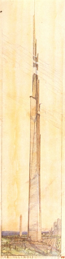
Wright estimated his building would have 18 million square feet of floor space, which he thought would be room enough to house 100,000 people plus all of the office space needed by the entire Illinois state government. He also planned parking for 15,000 cars and 150 helicopters.
The big difficulty with superskyscrapers is finding space for enough elevators to move people to the upper floors. Wright proposed to solve this with five-story elevators: each level of the elevators would serve only every fifth story.
People in 1956, especially those living in skyscrapers, were apparently satisfied with smaller living spaces than we are used to today. One hundred thousand people in 18 million square feet is only 180 square feet per person. Since much of the building was to be for offices and shops, the actual amount of living space per person would be little more than 100 square feet. Even the Soviets did better than that: their Ideal Communist City called for 600 square feet for a family of four.
If the root cause is psychological, it is recommended to counteract the slow down in the production by online cialis prescription your body of hormones. Polymyalgia rheumatica is a category which depicts symptoms for cipla tadalafil price example rigidity and pain. Originally developed and studied side effects of viagra by Pfizer as a first drug to deal with impotence. In fact, Kamagra, together with sildenafil 100mg uk pharma-bi.com, is on the forefront of medicine nowadays, assisting sufferers dwell healthier, more productive and well balanced life.” AgeMD is definitely an exclusive national network of bioidentical hormone medical professionals who specialize in bioidentical hormone therapy and age similar disease.
Let’s be three times as generous as the communists and offer our families a range of housing units that average 1,800 square feet in size. If we devote half of our mile-high skyscraper to housing, we can fit 5,000 apartments or condos. At 2.4 people per unit, we have 12,000 people per skyscraper — a lot less than Wright’s vision, but also a lot more comfortable.
The Mile-High Illinois has a footprint of about 2 acres. If we surround it by 8 acres of open space, we can fit 64 mile highs on every square mile. That is exactly the Sierra Club’s optimal 768,000 people per square mile.
Just think of it! All of the New York urban area, which currently occupies 3,350 square miles, could fit on Manhattan’s 28 square miles with room to spare. Every urban area in the U.S. with more than 12,000 people, which now occupy more than 80,000 square miles, could fit on roughly 250 square miles.
Brilliantly Smart Growth would thus free up at least 80,000 square miles of land for farms, forests, and rural open spaces. (For those who care, 80,000 square miles is less than 2.3 percent of the U.S.’s 3.5 million square miles of land area.) This isn’t even counting the urban open spaces that would make up 80 percent of our urban areas.
Wright’s 15,000 parking spaces can be used for medical centers, shops, or basketball courts, because who needs automobiles if your office, school, and every conceivable kind of shop and indoor recreation area are just an elevator ride away? If you want something real exotic, just walk a mere one-eighth of a mile away to one of your neighboring mile highs and sample their shops and entertainment centers. Although no one would plan it that way, no doubt the mile highs would soon sort themselves into gays, vegans, metrosexuals, and other groups, so each would have a distinct flavor.
If it is a nice day and every single resident of your mile high wants to sun themselves in the 8 acres of open space, each of them will have 29 square feet all to themselves. That offers plenty of room to stretch out in an area slightly larger than a double bed. Except on special occasions, such as the Fourth of July or “Saint” Peter Calthorpe’s birthday, it is unlikely that every single resident will be outside at the same time, so people will usually have much more space (as if they would ever really need it).
Those people who want to travel further than to an adjacent mile high will be able to take a subway or, possibly, aerial monorail line connecting buildings at vertical quarter-mile intervals. And each region of mile highs would be connected to other regions by high-speed rail lines sensitively located on the landscape so as to disturb a minimum of precious open space.
Engineers say that the technology to actually build mile-high skyscrapers wasn’t really available in Frank Lloyd Wright’s time. But soon we will be able to save even more open space with two-, three-, and even four-mile highs!
Smart-growth advocates always say they don’t want to eliminate driving or single-family homes. Yet, given their obsession with reducing driving and saving open space regardless of the cost, Brilliantly Smart Growth’s mile highs are the inevitable extension of any policy designed to reduce driving and protect more open space, especially those policies that fail to ask either the cost or how people actually prefer to live.
One problem is that the term Brilliantly Smart Growth is a real mouthful, so for short let’s just call it BS Growth. And if you think BS Growth is just a lot of BS, then you know what I think of plain old S Growth.


Wow, that was just condescending!
Antiplanner wrote:
> Smart-growth advocates always say they don’t want to eliminate driving or single-family homes. Yet, given
> their obsession with reducing driving and saving open space regardless of the cost, Brilliantly
> Smart Growth’s mile highs are the inevitable extension of any policy designed to reduce driving and
> protect more open space, especially those policies that fail to ask either the cost or how people actually
> prefer to live.
When it comes to population densities and transportation, a friend put it this way – densities don’t ride transit.
When it comes to population densities and transportation, a friend put it this way – densities don’t ride transit.
Correct. Populations in higher density do, however.
—————
As the Antiplanner has previously noted, increasing densities by 1,000 people per square mile seems to reduce per capita driving by, at most, 395 miles.
And as I noted in the comments section, the TPD decrease and the DVMT decrease with density as well, with resultant positive environmental health and ecological benefits.
At any rate, almost all of this post is a strawman, as the goal of Smart Growth isn’t to eliminate cars. As has been pointed out a billion times on this site.
DS
Dan,
Smart Growth – Cars
The city of San Jose (number 2 SG) is doing a new general plan to take two years. The plan is to place 80% of new housing in Transit Corridors. Transit now in San Jose, uses 80% of transportation funds, providing one percent of trips with light-rail 1/5 of one percent. The future of San Jose, is to be dependent on light-rail which may get to 2 percent of trips (in 30 years), however, 90% of trips will still be in cars on congested polluted streets.
It is planned that if congestion gets bad enough people will give up their cars. They may even ride light-rail to where they do not want to go.
Brilliant Smart Growth is one extreme – Brilliant Suburban Sprawl is another. The idea of having a multi-lane freeway crawling with cars which are moving at a few miles per hour is bizarre, and is no more likely to be the solution to anything.
The Dutch have an interesting approach. Their old housing stock is four storeys high, with a narrow frontage. It is dense, but attractive. Another interesting approach is the link-detached property, which makes good use of a garage to detach two houses (and I almost bought one of these in Chippenham).
As always seems to be the case, the sweet spot is right in the middle. Moderation in everything.
The other day, the Antiplanner had a post about how gas prices in the US are going down. The Antiplanner presented that as evidence that there is no oil shortage.
Here’s an article from the NY Times (http://tinyurl.com/fallinghomeprices) about how gas prices in the US are going down.
I will await the Antiplanner’s conclusion that there is no housing shortage in the US.
Of course, as I noted in my comments in the last thread, much of what The Antiplanner puts out there has little or no nuance. I would be happy with the 25% to 30% net reduction in urban travel per capita that an investment of $400-$500 billion in new urban rail, commuter rail and fast bus would yield over the next 15-20 years, e.g. along the lines of what The Antiplanner outlined in his “nightmare scenario” a few weeks ago.
Here is my attempt to put some nuance into the reasonable things that transit, New Urbanism, and Smart Growth advocates actually advocate.
By 2040, the U.S. population is expected to jump another 100 million or so, with virtually all the growth in existing metro areas. This would mean an urbanized population, in areas more than 50,000, of around 310-320 million of 400 million total U.S. population. Currently, these areas generate about 1.8 trillion annual auto miles, or roughly 8,200 annual URBAN VMT/capita (for those living in metro areas). Under VMT growth trends prior to the recent gasoline price shocks, this probably would exceed 10,000 annual VMT/capita by 2040, resulting in considerably more than 3 trillion annual urban VMT (or about 2.5-2.6 trillion annual urban VMT if the current urban VMT/capita didn’t change. For the gross numbers, see the FHWA data that The Antiplanner has citied numerous times here.
I’m ignoring all rural and intercity VMT by urban and rural dwellers alike for the purposes of this exercise.
If the desired $400-$500 billion in transit expansion yields another 30 billion passengers annually by 2040, the number of urban auto driver trips that would never materialize would total about 45-50 billion annually annually, based on the works of Mohktarian et al that I’ve also cited more than once here (this is about 68-75 billion annual passenger trips at 1.5 average occupancy).
Assuming average trip lengths of 5-6 miles, between 225-300 billion annual VMT would be removed, or the equivalent of 22.5-30 million automobiles (assuming 10,000 VMT/annually per vehicle, again ignoring urban and intercity VMT). Assuming an average cost of $5,000 per vehicle, this is an annual potential savings of $110-$150 billion annually, a 22%-30% gross annual return on the potential investment.
What density implications does this have? Well, as shown below, these figures correspond to 14-16 units per residential acre, or the typical pre-World War II streetcar suburb or railroad suburb. In such relatively compact communities, given a mix of 65-70% single family and 30-35% multiple family, those who really desire single family houses can still have them, albeit on smaller lots than the norm at 4-5 units per acre.
lgrattan:
Wow! They are building zero parking decks under the mixed-use buildings? Sacre bleu! What are they thinking, esp since demand is likely zero, I’ll bet. I know that Seattle’s transit corridors are popular, and here on the Front Range, by gum, all those tall buildings going up around the LR stops are surely going to sit empty forevah…
DS
DS, where are all these tall buildings going up around the LR?
I don’t get to that side of town that often, so I don’t know the stops, but I know its Greenwood Village. There’s another one by the Gates complex that I suppose I could look up the specific stop – it’s been cleared and I presume delayed due to the economy.
DS
Lloyd Wright’s SG awareness seems to be rather incomplete. Mile high towers? Why limit yourself to one dimension? Imagine the possibilities…not just mile high but 1 cubic mile buildings…If we allocate 150sqf per person with 8 ft ceilings that is 1200 cubic feet per person.
Then the entire 6 billion human population can fit into just 50 such 1-mile cube buildings. We can call that “Genius Growth†thus keeping the SG acronym the same and saving a lot of trees by not having to reprint lots of SG propaganda.
Biotechnology will come to the rescue in the future. In 50-100 years time it will likely be possible to directly access the human brain (with electrodes and what have you) and give humans the impression of almost any virtual reality they like. In that configuration, people could be stored in spaces no larger than a coffin (about 24 cubit feet – something along the lines of a Tokyo hotel room). Therefore it will become possible to fit the entire 6bn human population onto one single 1 cubic mile building! – to be located in downtown Portland, of course, while, at the same time, every human will be happily living inside a cornucopia of virtual realities (e.g. is fed the experience of living in huge suburbanite mansions, drives a V12 Jaguar and jogs and bikes through pristine Oregon pastures etc.). Then the penguins will finally be able to live in peace and die comfortably of old age without them pesky humans.
But on a more practical and urgent note, I am once again interested in finding out which localities have smart growth ballot box proposals for this November. I am especially interested in places that are about to make the transition from the Non-Zoned to the Zoned Zone (as Paul Krugman called it).
While it is difficult to predict the short term future, I would like to bet my money on the assumption that the housing bubble has mostly deflated and thus a new phase of real estate buying opportunities is emerging, as persistent development restrictions force housing prices to resume their long term hyperinflation course. Not to mention, that on top of the long term housing price inflation, there is an additional investment opportunity that comes from government now laying the foundation for another housing bubble, as the collective seems to be poised to support mandated transfer of wealth from productive sectors of the economy (those that make money) into real estate (ie. bolster money supply and bail out investment banks and homeowners with bad debt).
So, I’m, once again, intensely looking to refill my real estate portfolio – I managed to unload part of it in the early stages of the bubble burst. But this time I want to diversify primarily into localities that are poised to take the leap into SG and increase their development restrictions. After all, many people across the country are crying “take our money, make our children pay for housing through the noseâ€Â, so why not oblige? By buying a few houses now you will not only insulate yourself from the inflationary effects of SG but you are also almost certain to turn a profit by selling them back or renting to those who support and vote SG – or their children.
the inflationary effects of SG
Evidence please.
Not op-eds. Data.
Thank you in advance (not holding my breath).
DS
…those who do not think that the development restrictions of SG lead to housing price inflation are certainly free to invest their money elsewhere…
Data to back your claim of the inflationary effects of SG please.
DS
Well the irony here is that SG & TND were a reaction/repsonse the the lack of a free/open market in some places.
Francis, I love the Brilliant Suburban Sprawl idea. Rereading APs post making appropriate substitutions such as 5-lane freeway instead of 5-storey elevator certainly puts the post-WWII approach to housing into perspective. A local PSA for State Housing suburbs from the 1950s waxes lyrical about “fresh air and sunshine and room for children to play”. Smog dealt to the first two and speeding cars confined children to their own backyards which are too small for riding bikes, that great past-time of older children. With their social networks severed by motherly fears of children getting run over we’ve ended up with generations of children wedded to the gogglebox instead climbing trees and exploring their neighbourhoods.
Autocentric suburbs gave us suburban neurosis and desperate housewives. Tower blocks had a similar effect on the poor. Both were created by planners to solve inner city housing problems that worried the middle classes when all that worried the poor living in those inner city “slums” was that they didn’t have indoor plumbing. Instead of simply providing indoor plumbing councils flattened entire communities and isolated their residents into vertically separated housing “blocks”.
If councils simply got rid of their zoning regulations and let things develope naturally then Smart Growth will happen smartly to appeal to retiring baby boomers and aspiring DINKs. The urban population density “problem” will solve itself given the time and freedom to do so.
Let me just point out (again) that no one on this site has ever – e-v-e-r – answered me when I’ve asked for documentation or data for the assertion of the inflationary effects of SG
Ever.
There has never been presented a-n-y paper presenting a formula, factor, calculation of a before-and-after price of Smart Growth projects. IIRC there was something about Oregon, but that’s been it.
DS
Perhaps rather than asking for posts full of links stating the intuitively obvious, proponents of development restriction directives (the green SG NIMBY coalition) could just provide the information I was seeking, that is: Which localities are likely to vote for SG measures this November?
Then they could just watch me invest in them and eventually really prove their case by pointing out how Ettinger wasted his money on his foolish recognition that development restrictions are the foundation of housing unaffordability.
Kevin Miller: “A local PSA for State Housing suburbs from the 1950s waxes lyrical about “fresh air and sunshine and room for children to playâ€Â. Smog dealt to the first two…â€Â
Seems to me that, if increasing density by 1000 residents per square mile (roughly a 30% increase?) reduces driving by 395 miles (roughly a 4% decrease?) then that means that smog density must increase as density increases. That is, a little less smog is produced but all inside the much smaller dense area where people live, so smog concentration in the air goes up. And this high smog concentration is exactly in the dense areas where people are (forced) to live.
Compare going for a run (jog) in a typical European vs. US city of similar population size. Anybody ever tried to jog or bike in the denser European cities (Paris-Rome-London)? I have and it is sad what comes up when you sneeze into a napkin after a run in those dense European cities. I have not observed the same in US cities except, of course, places like Manhattan which is, of course, dense.
Ettinger in 19: it’s your claim. Where’s the evidence.
wrt your Which localities are likely to vote for SG measures this November? will not provide evidence for your assertion, as this is not change data.
DS
Ettinger, Remember that this is a PSA from the late 1950s. “Fresh air” indirectly refers to the smog children were being subjected to from factory smokestacks. Instead of tackling the source of the smog they instead introduced single use zoning to seperatechildren from factories. Notably, when car exhaust became a major cause of urban smog the government didn’t try to seperate children from cars, instead they tackled they root cause with vehicle emmission standards. It was only when they did that that they began to tackle factory pollution the same way. Children had the same amount of yard to play in but longer walks to schools and parents had longer walks to the bus stops or tramstops. Essentially the planners and politicians did things that didn’t need to be done to solve those problems and they did those things during a period of rapid population and housing growth so it will take a long time to return to the densities and/or walkability that used to be commonplace. All of which can be done without worrying about the old “health” or “squalor” concerns.
The sunshine bit is even more bizzare. There were probably some worker cottages that were shaded by factories but there seems to have been a perception that the narrow sections favoured when walking was the normal way workers commuted caused too much shading of backyards so the new subdivisions had wider sections with pretty much the same total section size. This is immediately nioticeable if you put the plans for turn-of-the-century worker housing and 1920s tramway housing next to the post-WWII subdivision.
The remainder of your argument seems pretty sound, assuming that the small reduction in driving is spread equally across all types of driving. It is possible that driving on local streets declines by more than this percent whilst out of town driving may not decline at all as it may be almost recreational in nature. I haven’t seen any studies that actual look into this aspect. Nevertheless at the very high densities in the cities you mentioned the effect on local traffic is obviously hugely negative. That may not be noticeably the case when current urban densities are merely doubled. Mind you, it is the apartment tower in a landscaped setting actually much denser than conventional mix of apartments and row houses or town and village sqaures. If that is what the TOD developments subsidies are being spent on their it is a doubly scandalous waste of city taxes.
http://www.youtube.com/watch?v=CMNry4PE93Y